Snow blankets NYC and Tri-State Area in 1st round of wintry weekend weather
The first of this weekend's two rounds of snow blanketed the Tri-State Area on Saturday.
Overnight, clouds remained in place, and with lows ranging from the mid 20s to low 30s, refreezing of any melted snow on roadways and sidewalks was certainly possible.
How much snow did the NYC area get Saturday?
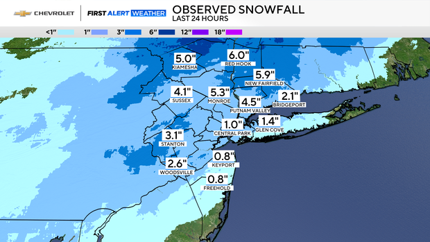
As expected, areas north and west of the city had the highest totals, averaging between 2-5 inches. Red Hook, New York, reported 6 inches. New Fairfield, Connecticut, was just shy of that with 5.9 inches, and Hardwick reported the highest totals in New Jersey with 5 inches.
South and east of the city, snowfall amounts were generally less than an inch.
Within New York City, 1-2 inches fell, putting us close to our seasonal average to date. Dongan Hills on Staten Island had the highest snow reports at 2 inches, followed by Flatbush, Brooklyn, with 1.6 inches.
Saturday offers preview of more winter weather to come
Some in the Garden State were caught off-guard by Saturday's snow.
"I woke up in the morning, and I never check outside, you know, and my mom's like yelling like, 'Oh my God, it's snowing,'" Mason Henry, of Wallington, said.
Parts of Bergen County saw nearly 4 inches, giving Mason and his friends just enough to go sledding in a local park.
"For me, it's fun to sled and stuff. Just like, you can spend time away from the devices and stuff," one boy said.
Meanwhile, plows got to work clearing roadways. It was an apparent dry-run for what will probably be the weekend's main snow event on Sunday, where portions of central and northern Jersey could see anywhere between 2-5 inches.
Shoppers were not taking any chances, grabbing a couple of last-minute necessities at Shop Rite.
"The forecast is the forecast. If it's coming, I am ready," one shopper said.
Tri-State Area bracing for 2nd round of snow arriving Sunday
New York City is also getting ready, activating its winter weather emergency plan and issuing a travel advisory for Sunday, where parts of the city could see 2-4 inches.
"It could be a little slippery and treacherous outside. If people don't need to travel tomorrow, we would advise them to stay home," said Christina Farrell, first deputy commissioner of the New York City Office of Emergency Management.
A black ice warning is currently in effect across the five boroughs, where temperatures are expected to drop overnight.
Back in New Jersey, the National Weather Service has issued winter weather advisories for 15 counties in the state, where harsh driving conditions are expected. They go into effect at 6 a.m. and will continue through Sunday night.