Severe weather in NYC area brings hail, damaging winds

Storms hit the New York City area on Saturday, bringing damaging winds, hail and downpours across the region.
Showers will clear out during the overnight period. Lows will mainly be in the 60s to around 70 in most locations.
Storm damage
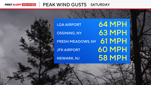
There were reports of wind gusts in excess of 60 mph across the region, which led to wind damage, including many downed trees.
The New York City Parks Department said as of 10 p.m. Saturday, there were over 250 reports of downed trees across the city, though they noted the department often receives duplicate reports.
In Astoria, Queens, a tree fell onto the road near Astoria Boulevard North and 77th Street, almost crushing parked cars.
A tree fell onto the Brooklyn-Queens Expressway in Woodside, causing delays in both directions. Videos appeared to show a car underneath the tree, but there were no immediate reports of injuries.
Energy companies across the Tri-State Area also reported hundreds of power outages, and some local airports reported flight delays due to storms.
Quarter-sized hail was also reported in Sullivan County.
The CBS News New York weather team had live storm updates throughout the evening streaming on CBS News New York.
Sunday forecast
Bright skies will kick off the day on Sunday, with a few more clouds and an isolated shower later in the afternoon.
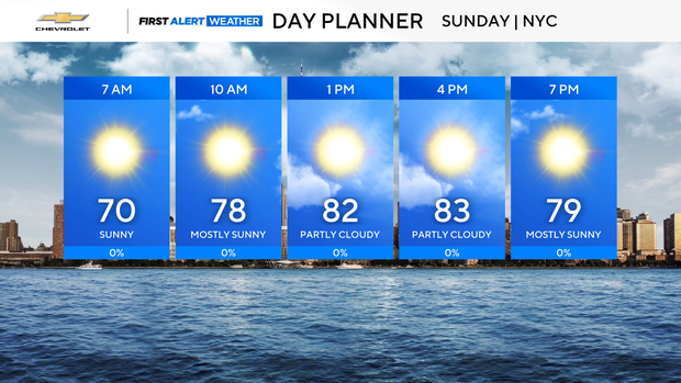
Highs will reach the low to mid 80s, making for a great day for the Queens Pride Parade and the beach. A moderate risk of rip currents will be in place for all ocean beaches.


