Arctic front brings brutally cold temperatures to Tri-State Area on Monday. Here's the latest forecast.
Sunday's weather was calm and pleasantly chilly, but big changes are in store as we begin the new work week.
If you're stepping outside Monday morning, brace yourself — it's downright brutal out there. We're talking very cold and breezy with wind chills dipping into the 20s, teens and even single digits in some spots. So in addition to the heavy coat, you'll want all the accessories.
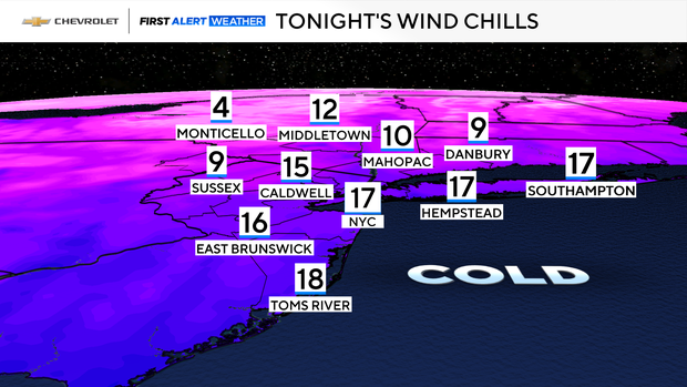
As an arctic front moves through, temperatures plummeted into the 20s Sunday night. Winds also picked up, making those 20s feel like the teens and single digits through Monday morning.
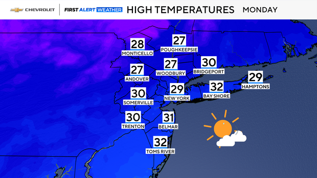
With the frigid airmass in place, highs on Monday won't make it out of the 20s, which would be the coldest daytime to date this winter.
As winds relax on Monday night, we are then likely to have our coldest night of the season so far, as lows drop into the teens and single digits regionwide.
As for the rest of the upcoming week, temperatures will briefly return to average levels by Wednesday before dropping again as the week ends.
So far, December has been running much colder than normal, and that trend is expected to continue for the foreseeable future.
Our next chance of precipitation comes on Wednesday, but the event looks minor. Many locations will likely see just plain rain, while the northwestern suburbs may see a period of light snow.