First Alert Forecast: Spotty showers, possible thunderstorm Saturday, but not a washout
Spotty shower today? Yes. Risk of a gusty thunderstorm later? Yes. A Washout? By no means!
It'll be a mostly cloudy day overall, but it really depends on where you are. Farther north, more clouds and a better chance to see a passing shower. The farther south you go, the more sunshine you'll see.

Much of the daytime hours will be dry. Highs will range from the upper 50s along the coast to near 70 for inland New Jersey. The city should top out in the low 60s this afternoon. Not bad!
The risk of any severe weather holds off until this evening. That's good news, as a line moving into western New Jersey by 7 p.m. or so will weaken as it heads eastward toward more stable air. Hence, the greatest chance of any severe storms will be for points north and west.
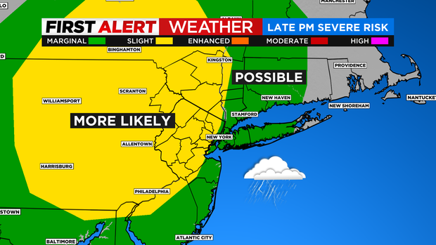
Damaging wind gusts would be the main threat with any that develop. Any leftover showers or rumbles will clear the east end by midnight.

Sunday will be the "drier" day, although a spotty shower can't be ruled out late. After a bright start, some more clouds swing through by afternoon. Temps will be slightly cooler tomorrow, in the mid to upper 50s with a northwest breeze. Still above normal as spring arrives!
As of now, Monday looks great with bright skies and temps around 60 degrees.

Just keep an eye out this evening for a few storms if you have outdoor plans. Have a great weekend!