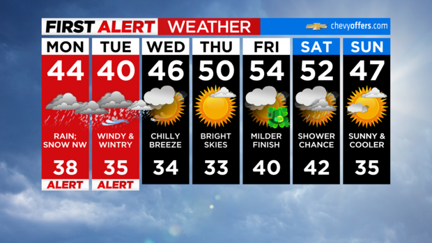
First Alert Forecast: Nor'easter hitting NY, NJ, CT with rain, snow, coastal flooding risk
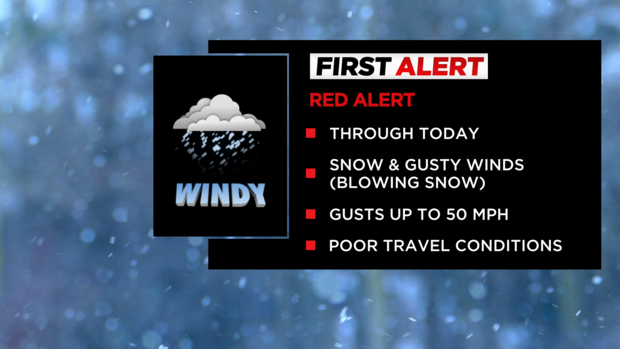
get the free appNEW YORK -- We've issued a Red Alert on Monday and Tuesday as a strong nor'easter develops and is poised to bring multiple hazards, including heavy rain and snow, strong winds, and coastal flooding.
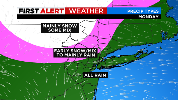
This storm has been tricky to forecast, but it appears that the heaviest snow will stay to the north and west of New York City.
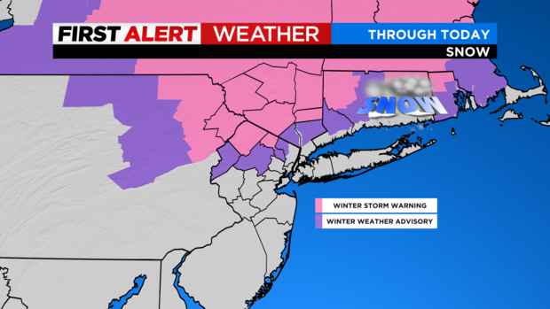
The highest snowfall totals are likely to be across northwestern New Jersey and the far northern suburbs, where some may see snow in excess of 12 inches.
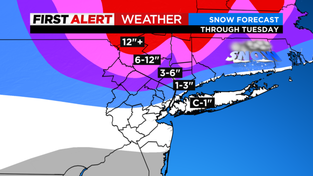
For NYC and points south and east, a general 1-2 inches is likely. For areas that see rain before the changeover, expects up to 2 inches.
Due to the strong winds, and the storm's duration, power outages are very likely. For areas that see the higher snowfall totals, the heavy and wet nature of the snow may also cause power outages.
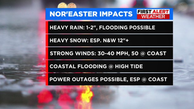
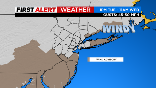
Wind advisories have been issued for Ocean, Monmouth, Mercer, Suffolk, and coastal Fairfield Counties on Tuesday afternoon through Wednesday morning. Peak gusts of 40-50 mph are possible in these areas.
Check this live blog for updates!
Fear of rapid snow melt on the minds of residents in northern suburbs
As people across the Tri-State Area dig out from the snow, some towns are now looking ahead to another concern: the effects of a rapid warm-up.
Some of the sidewalks in the Orange County were still buried on Tuesday night, but the streets in Monroe were clear. That doesn't mean driving was easy, because the wind was creating hazardous conditions.
The rumble of snow blowers and the scraping of shovels was the soundtrack of Monroe, where the National Weather Service reported 15 inches of snow in one part of town.
Watch Lonnie's forecast
Snow creating hassles in Orange County
Hour by hour, inch by inch, snow is putting a frosty layer of white in Orange County.
It's hard work removing it from roads and sidewalks.
"It's going to take me about 35 minutes, and I have been out here for about 10," said Gary Shaw of Goshen. "And it is heavy, real heavy, so you've got to take your time a bit."
Not far from West Point, a coat of wet snow weighed down trees. There's concern that the wind will pick up and tree limbs will come down.
Utility crews are standing by.
"We had a power issue in one area where the weight of the snow tripped a breaker, so the weight is a factor. We're expecting a little big more snow today, some wind, but overall we've fared pretty well for this storm," said Emergency Services Commissioner Brendan Casey.
During the morning commute, drivers struggling in the snow forced state police to shut down Route 6 in the town of Woodbury. A medical transport van was among the vehicles that slid off the road.
Across the Hudson, in Westchester, officials are urging drivers to obey those signs urging them to slow down, even on roads that look clear.
"You can't drive in a snowstorm like you do in August. You may have four-wheel drive and you're coming down an icy hill, all that is, it's more tire patch on the road that makes them slide even easier than a bicycle," said Yorktown Highway Supervisor Dave Paganelli.
Tree crushes car in the Bronx
A tree in the Norwood section of the Bronx fell onto parked cars.
It happened during Tuesday morning's nor'easter.
Neighbors near the intersection of Mosholu Parkway and Bainbridge Avenue woke up to the sounds of chainsaws.
"Glad nobody got hurt. That's all that's important right now," said Efrian Nieves, the car's owner.
CLICK HERE to read the full story.
Gov. Murphy gives update on conditions in New Jersey
NJ State Police: Driving conditions will get worse
New Jersey under state of emergency, travel restrictions
Raining on Long Island, flooding possible
Snow starting to pile up in Orange County
Precipitation begins to fall in northern suburbs
The region is about to be hit with a nor'easter that's expected to cause damage. Rain started coming down in the northern suburbs on Monday night.
People are being urged to stay inside as the storm is expected to continue through Tuesday. Officials are warning it has the potential to be deadly.
Conditions are already proving to be difficult on some roadways.
New York and New Jersey have declared a state of emergency. Gov. Kathy Hochul says resources will be deployed throughout the night to make sure roads are plowed and streets are cleared.
State officials say utility crews from different cities are in position, and the National Guard is ready to step in to help.
In Orange County, CBS2 saw some folks stocking up on salt and other necessities.
Meanwhile, some schools have already announced they're closed on Tuesday.
Again, if you don't need to be outside on Tuesday, don't go out.
Keep in mind, power is expected to go out in some areas. You may want to keep additional light sources nearby.
Preparations being made in New York
New Jersey gearing up for storm's impact
The northwestern part of New Jersey is expecting up to a foot of snow, and down the Jersey Shore, residents will be dealing with tidal flooding and strong winds.
Christine Sloan has a look at preparations in Sea Bright and across the Garden State.
CLICK HERE to read more.
Gov. Kathy Hochul declaring state of emergency starting Monday night
The brunt of the storm is expected to hit upstate and in Western New York.
A state of emergency will be in effect from 8 p.m. on in the following counties: Albany, Broome, Cayuga, Chenango, Columbia, Cortland, Delaware, Dutchess, Essex, Fulton, Greene, Hamilton, Herkimer, Lewis, Madison, Montgomery, Oneida, Onondaga, Ontario, Orange, Oswego, Otsego, Putnam, Rensselaer, Saratoga, Schenectady, Schoharie, Schuyler, Seneca, Sullivan, Tioga, Tompkins, Ulster, Warren, Washington, Wayne, Yates and contiguous counties.
"New Yorkers should prepare now for a multi-day event that will bring up to three feet of snow in certain parts of the Capital Region and Mid-Hudson region," Gov. Kathy Hochul said. "State agencies spent the weekend preparing emergency response assets, my team is in constant contact with local officials, and we have activated the National Guard to assist with emergency response. This storm will create hazardous road conditions through Wednesday morning, and I encourage New Yorkers in impacted regions to stay home and avoid any unnecessary travel to allow plow crews to do their job."
NYSDOT has issued the following commercial vehicle restrictions:
- I-84: Full length. 8 p.m. start; No tandem or empty tractor trailers
- I-88: Full Length. 8 p.m. start; No tandem or empty tractor trailers
- I-87 (Northway): Albany To Plattsburgh. 8 p.m. start; No tandem or empty tractor trailers
- I-90: I-87 to Berkshire Spur. 8 p.m. start; No tandem or empty tractor trailers
- I-81: PA Line to Syracuse. 8 p.m. start; "Trucks Use Right Lane" advisory
- Route 17: Middletown to Binghamton. 8 p.m. start; "Trucks Use Right Lane" advisory
Storm Timeline
Monday 5 a.m. to 9 a.m.: Rain moves into the majority of the area; snow falls in the northwestern zones.
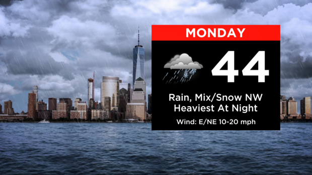
Monday 9 a.m. to 9 p.m.: Most see rain, may be heavy at times. Snow ongoing in the northwestern suburbs, especially in Sullivan, Ulster, and Dutchess Counties.
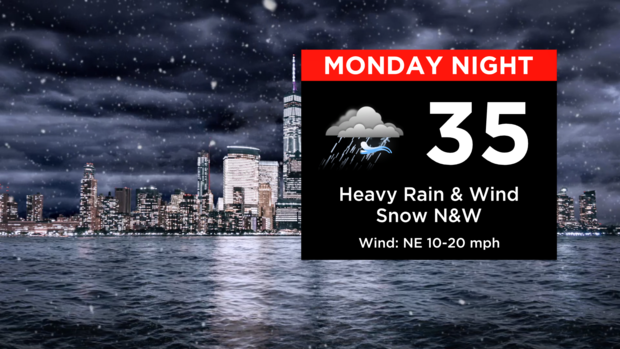
Monday 9 p.m. to Tuesday 2 a.m.: The heaviest rain shifts to the East End of Long Island. A heavier band of snow develops from far northern Sussex County into Orange, Sullivan, and Ulster. Snowfall rates may reach an inch per hour at times. Winds begin to ramp up for nearly everyone; gusts in the 20-30 mph range.
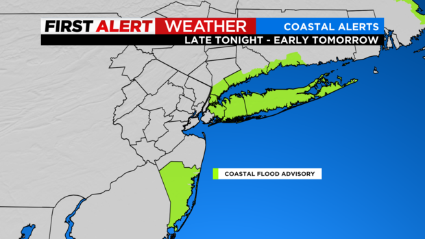
Tuesday 2 a.m. to 7 a.m.: Precipitation starts decreasing in intensity and coverage; moderate snow still falling across the northern counties. Winds remain gusty. This is the timeframe with the greatest chance of coastal flooding due to the high tide cycle.
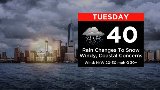
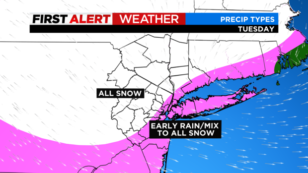
Tuesday 7 a.m. to 1 p.m.: As cold air gets drawn into the system, rain turns to snow for everyone. Snow will come in bursts, not constantly falling. Exceptions are in Sullivan, Ulster, and Dutchess. Winds get even stronger; gusts up to 40 mph. Isolated gusts over 50 mph are possible.
Tuesday 1 p.m. to 11 p.m.: Bands of snow continue pivoting through the area. They will vary in intensity, with the heaviest occurring north of NYC. Gradually, bands transition to snow showers and flurries. Strong winds remain in place. Windchill values in the 20s.