NEXT Weather: Twin Cities hits another record high Thursday
MINNEAPOLIS -- More record-setting heat arrived in the Twin Cities on Thursday.
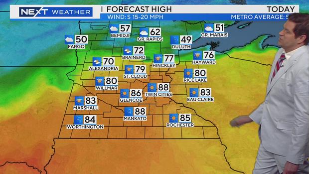
In the mid-afternoon, 85 degrees was recorded at Minneapolis-St. Paul International Airport, which breaks the previous record of 84 degrees in 2006.
And it could still get warmer -- the forecast high is 88.
There will also be plenty of sunshine. Southern Minnesota will also be hot, while temperatures up north will be more seasonal. Rain showers are possible in northern Minnesota, too.
Red flag warnings will be in effect from 11 a.m. to 8 p.m. for southern Minnesota up through the Twin Cities. Residents should avoid burning, as conditions are ideal for wildfires.
The night will be mild before another warm day on Friday, with temperatures expected to top out around 80 before rain and possible storms move in later in the day and overnight.
Rain will arrive in western Minnesota in the afternoon, and the Twin Cities will see showers in the afternoon and overnight hours.
Over the weekend, temperatures will fall to more seasonable territory. Rain and even a few snowflakes are possible. It will stay windy and get cooler with a high near 44 on Sunday.
Temperatures will warm up again next week, though we won't hit the highs seen this week.