Light snow in Twin Cities Wednesday before arctic air pours in


Wednesday features light snow to the Twin Cities and other parts of Minnesota before a sharp turn to dangerous cold.
A round of organized, light snow will mainly affect areas south of Interstate 94. Spotty showers should hang around into the evening commute. Most spots will see around an inch of accumulation.

Winds will increase Wednesday afternoon and evening, leading to areas of blowing snow, especially across western and southern Minnesota. Some schools in those areas are closing early.
Highs will be in the low 20s.
Arctic air will bring bitter cold across state
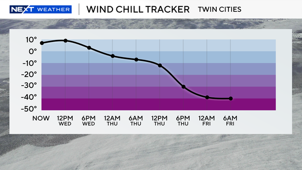
As the snow tapers off, arctic air will pour in behind it. The Twin Cities will wake up to single-digit temperatures and wind chills below zero on Thursday, but the bitter cold will really settle in come nightfall. It will be the coldest air we've felt in at least a year, according to WCCO Meteorologist Joseph Dames.
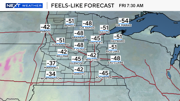
NEXT Weather Alerts are in place for Thursday, Friday and Saturday as the cold lingers, and the National Weather Service has issued an extreme cold warning for the Twin Cities, central Minnesota and the southeastern corner of the state. Lows will be in the double digits below zero, while highs won't climb into the positives. Wind chills will hover between 30 and 50 below zero.
It will remain cold through the weekend, with positive numbers returning on Sunday and double-digit highs to follow.