NEXT Weather: Winter storm wraps, but blowing snow lingers in Minnesota


A major winter storm that blasted Minnesota on Sunday is still impacting travel conditions on Monday.
Due to significant impacts from the storm, WCCO has issued a NEXT Weather Alert and a NEXT Drive Alert.
The National Weather Service has issued a winter weather advisory that's in effect until 6 p.m. for blowing snow and slick roads, but conditions should improve throughout the day.
Monday will be cold with highs topping out in the low teens, but wind chills will make it feel subzero. Expect some sunshine once the system clears out.
Highs will rise into the low 30s Tuesday, and another weak clipper may bring light snow north of Interstate 94. Wednesday brings a better chance for an inch or two of accumulation.
New Year's Eve night will be cold, with temperatures crashing to zero or below. The rest of the week turns colder and quieter, with temperatures remaining below normal.
Follow live updates below.
Weekend storm crash numbers
The Minnesota State Patrol says between 5 p.m. Sunday and 11:30 a.m. Monday, there were 201 reported crashes with property damage and 16 crashes that resulted in an injury.
During the same period, 19 vehicles spun out, 249 went off the road and 16 semitrucks jackknifed.
The agency is asking anyone who needs to travel to monitor the weather and road conditions.
"No travel" advisories pulled in most of Minnesota
Advisories not to travel in a large part of southwest and southern Minnesota have been pulled.
Still, travel is not advised near the southern border in Albert Lea and the immediate surrounding area, including Glenville, Mapleview and Clarks Grove. Interstate 35 remains closed for now.
Check the latest road conditions on 511mn.org.
St. Paul declares snow emergency
The City of St. Paul on Monday declared a snow emergency, with parking restrictions beginning at 9 p.m.
At that time, night plow routes will be plowed, so motorists should not park on these routes, which include downtown and all streets indicated with "Night Plow Route" and "Night Plow Route This Side Of Street" signs.
Vehicles not moved by 9 p.m. will be ticketed and towed.
More info on the city's snow emergency here.
Minneapolis and a host of other cities already declared snow emergencies on Sunday.
Metro sees nearly 6 inches of snow
As of 5 a.m. Monday, here are snow totals from across Minnesota and Wisconsin, according to the National Weather Service:
- Minneapolis-St. Paul International Airport: 5.8 inches
- Eau Claire, Wisconsin: 8.5 inches
- Burnsville: 7 inches
- Maple Grove: 6.2 inches
- NWS Chanhassen: 5.6 inches
- Duluth: 2.1 inches
Gov. Walz authorizes Minnesota National Guard to provide support amid snowstorm
Gov. Tim Walz declared a peacetime emergency and authorized the Minnesota National Guard to assist with emergency winter storm operations in southern Minnesota.
"During a time of peak holiday travel, the winter weather moving across the state poses a major risk for anyone on the roads," Walz said in a statement. "As we work to alleviate the dangerous conditions, I'm grateful to the National Guard for stepping up to help drivers get home safely."
Walz's office says the state received a request from the Freeborn County Sheriff's Office to "provide the personnel, equipment, facilities, and resources necessary to respond to the severe weather and rescue stranded motorists."
The executive order will remain in effect until emergency conditions subside or Friday.
Update on MSP Airport disruptions
There are now over 400 delays and nearly 150 cancellations at Minneapolis-St. Paul International Airport, according to flight tracker website FlightAware.
A ground delay is also underway at the airport with an average delay of four hours.
The airport suggests you pay close attention to your flight status with your airline.
MSP is still in the midst of its holiday travel period. The Metropolitan Airports Commission says that roughly 50,000 people were expected to travel through checkpoints across the airport system on Sunday
Minneapolis declares snow emergency
Minneapolis has joined the growing list of cities in the state to declare a snow emergency. Parking rules begin at 9 p.m. on Sunday.
St. Paul has yet to announce a snow emergency, but city officials did issue an update at 2 p.m.:
"Currently, Saint Paul Public Works has additional crews plowing arterial (main, high volume) streets throughout the city. With the heavy snowfall, crews will continue to plow "center cuts" to keep the drive lanes as open as possible throughout the day.
"Extra crews will be plowing snow throughout the evening, and as the snow slows, plows will then push accumulated and blowing snow to the curb.
"Crews will also be plowing and salting hills and curves throughout the city today and into the evening.
"Residential side streets will be snow covered and become compacted in areas by Monday. Please drive with extreme caution."
Other cities that have announced snow emergencies include:
- Eden Prairie
- Hopkins
- St. James
- St. Louis Park
- New Hope
- Northfield
- West St. Paul
There may be more, so see snow emergency information here.
Interstate 35 closures in southern Minnesota, northern Iowa
A stretch of Interstate 35 in southern Minnesota is closed due to numerous crashes amid a winter storm.
According to officials, the interstate is closed from Highway 14, which is just south of Owatonna, to Clarks Grove. There are at least five crashes between those two locations.
At 4 p.m. the interstate is also expected to close from Albert Lea into northern Iowa. It's a coordinated effort between Iowa DOT and MnDOT. The interstate is expected to open on Monday, but no specifics have yet been given.
See the latest road conditions on 511mn.org.
Metro Transit's status
A representative of Metro Transit says "things are going pretty well overall."
As of 1 p.m., a third of buses were delayed by about 7 minutes and light rail service is "largely unimpeded by the weather," the representative said.
Service updates will be posted via Metro Transit's social media accounts.
Trollhaugen closes Sunday due to power outage
Trollhaugen, a ski area in Dresser, Wisconsin, has closed Sunday due to a power outage. Organizers say the power went out at 11:30 a.m. and that it's expected to be restored by 4:45 a.m. Monday.
Travel not advised for large part of the state
According to Minnesota transportation officials, travel is not advised for most of southwestern Minnesota due to low visibility amid Sunday's winter storm.

Snow emergencies begin to pile up
Multiple cities announced snow emergencies:
- Eden Prairie
- Hopkins
- St. James
- St. Louis Park
- New Hope
- Northfield
- West St. Paul
Crash numbers update
The Minnesota State Patrol has issued an update on crashes between midnight and 1:30 p.m., adding to "please delay or cancel travel plans until the storm as passed."
According to the patrol, there have been 179 property damage crashes, 163 vehicles off the road, 12 injury crashes, five spinouts and seven jackknifed semis.
Thousands without power in metro area
Power outages are an issue during the winter storm on Sunday.
According to Xcel Energy's outage map, there are nearly 2,500 people without power in the Twin Cities area.
Nearly 200 delays and dozens of cancellations at MSP Airport
Sunday's winter storm has led to significant delays and cancellations at Minneapolis-St. Paul International Airport.
According to flight tracker FlightAware, there are 197 delays and 60 cancellations at MSP Airport as of 11:30 a.m.
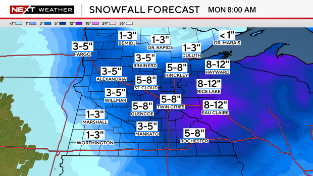
A look at potential snowfall totals
By Monday morning, the Twin Cities could see up to 8 inches of snow. Western Wisconsin could see even more, possibly up to 12 inches.
Areas to the north, south and southwest of the Twin Cities are expected to see less:
- Grand Rapids: Up to 3 inches
- Mankato: Up to 5 inches
- Worthington: Up to 3 inches
Follow snowfall totals from NEXT Weather Watchers here.