Showers, storms to linger across South Florida as first day of fall begins

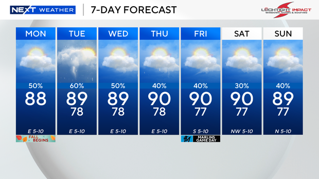
Although Monday marks the official start of fall with the autumnal equinox taking place at 2:19 p.m., it will still feel very much like summer across South Florida. And hang on to your umbrella.
Some areas are experiencing showers in spots, following a warm start to the day with temperatures in the upper 70s and low 80s across South Florida.
Highs climbed to the upper 80s Monday afternoon, feeling like the mid to upper 90s, before the rain brought some relief. Scattered storms and showers will increase in coverage throughout the evening, with the potential for some heavy downpours and localized flooding.
There is a low risk of rip currents along the Atlantic beaches, and the UV index is very high. There are no alerts or advisories for boaters along the Atlantic waters and the Keys waters.
Deep moisture hangs around heading into Tuesday, with plenty of cloud cover lingering through most of the day and some breaks of sun. Coastal showers will be possible in the morning, and then thunderstorms will develop and move inland throughout the day.
Flooding remains a primary concern with the possibility of some areas dealing with repeated rounds of rain over short periods of time.
On Wednesday, the chance of rain and storms decreases, however, scattered showers and storms will be expected in the afternoon and evening, with the possibility of coastal showers during the morning hours.
By late week and into the weekend, the chance of rain will continue to decrease, and it will heat up. Highs will rise to the low 90s as we head into the weekend.
Tropical outlook
Hurricane Gabrielle, the seventh named storm of the 2025 Atlantic hurricane season, strengthened to a Category 3 storm on Monday, but the system is not expected to impact South Florida, meteorologists say.