Heavy rain, localized flooding possible across South Florida on Wednesday
A wet Wednesday is ahead with rounds of rain expected to move across South Florida.
Later in the day, scattered to numerous storms will develop with the potential for heavy downpours and localized flooding. Highs will climb to the mid-80s due to the clouds and rain.
The UV index will be low today and there is a moderate risk of rip currents along the Atlantic beaches. There are no alerts or advisories for boaters along the Atlantic waters or Keys waters.
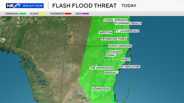
The Weather Prediction Center has placed Broward and Miami-Dade under a level 1 risk of flash flooding today, tomorrow and Friday. Deep tropical moisture along with a frontal boundary will keep the atmosphere moist and unsettled, leading to higher rain chances over the next few days.
Scattered to widespread storms will be possible again on Thursday with the potential for heavy rain and flooding. Highs will remain in the mid-80s.
Lingering moisture will keep us unsettled through Friday with scattered storms possible. This weekend, the chance of rain will begin to decrease. Spotty storms are expected Saturday and Sunday with highs in the upper 80s.
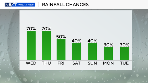
Early next week looks drier with only a few storms possible each day and highs around 90 degrees.
The CBS Miami Next Weather team is tracking Tropical Depression Seven in the Central Atlantic. The National Hurricane Center says it could become Tropical Storm Gabrielle later today or tonight. It is moving west-northwestward and expected to move northwestward over the next several days. It will likely stay north of the Lesser Antilles and then potentially move near or over parts of Bermuda late this weekend or early next week.
Elsewhere in the Tropics, a tropical wave in the far eastern Atlantic has a low potential (20% chance) of development as it generally moves westward.