Another round of severe weather possible for Southeast Michigan on Wednesday

Southeast Michigan is in the path again for possible severe weather, with the time frame of 1:30 to 5 p.m. Wednesday when the storms might happen.
Ahead of that, the National Weather Service in Detroit is showing Metro Detroit and nearby communities in the "slight risk" zone for severe weather. That's a 2 out of 5 on the severe weather risk; to compare, Tuesday's storms came amid an "enhanced risk" or 3 out of 5 on that scale.
With that forecast, the CBS News Detroit weather team has declared Wednesday to be a NEXT Weather Alert day.

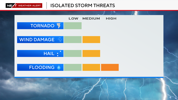
The best timing for Wednesday's storms will be from mid-afternoon through the evening, as daytime heating and incoming weather systems help storms develop and intensify. The main threats include damaging wind gusts (potentially 50–70+ mph), hail, and a low chance of a tornado, along with periods of heavy rain that could lead to localized flooding.
While not every area will see severe weather, multiple rounds of storms are possible, so conditions can change quickly — especially later in the day when the atmosphere becomes more unstable.
Because of the repeated rounds of storms, the NWS issued a flood watch for the region on Tuesday. The flood watch will remain in effect through late Thursday.
Watch vs warning
The National Weather Service says a severe weather watch means "be prepared." It is possible that the weather will reach severe levels during the time frame specified.
A severe weather warning means "take action," that severe weather conditions have been reported by spotters or can be detected on radar. People are asked to take shelter indoors, away from windows.
Storm surveys
The National Weather Service in Detroit has assigned two storm survey teams to visit multiple locations in its Southeast Michigan coverage area on Wednesday.
The storm survey is part of the process for confirming whether a tornado or straight-line winds caused damage in a given location from the storms that struck overnight Tuesday.


