Snowstorm in Massachusetts will bring a high risk for ice; maps show timeline and how much to expect
The forecast for snow and ice from a weekend storm in Massachusetts and the Boston area hasn't changed much in the past 24 hours.
This is going to be an extremely messy storm. It is absolutely loaded with moisture by winter storm standards.
This could very well end up being one of the most impactful and memorable storms of this entire winter.

This storm is coming in four parts:
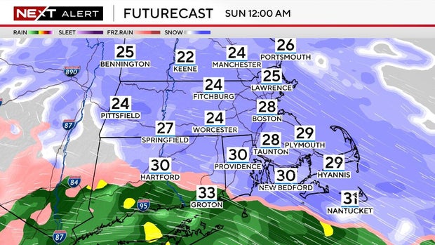
When does the snow start this weekend in Boston?
Part 1: The snow.
The storm starts as snow for everyone.
Steady snow is now falling in Massachusetts, New Hampshire, and Vermont. The form of precipitation will remain as snow through around midnight tonight before most locations start to see a change over to mixed precipitation."
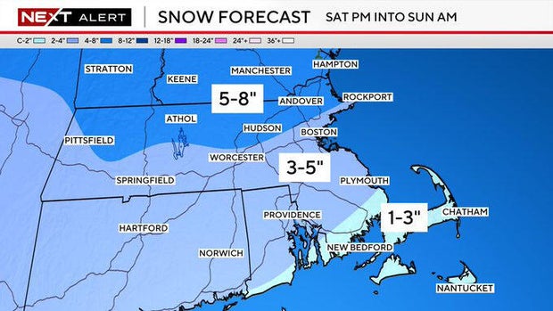
Snowfall accumulation will all occur in part 1 and will increase the farther north you live.
How much snow will Boston get?
We are forecasting 5-8" in northern Essex, Middlesex and Worcester counties as well as all of southern New Hampshire and Vermont.
There will be 3-5" near and south of the Mass Pike including Worcester and Boston and as far south as Providence and Plymouth. Much of this will be severely compacted or washed away on Sunday.
The lowest snow totals, 1-3", will be found over the South Coast, Cape Cod and the Islands. All of which will be washed away by rain on Sunday.
When does the ice storm start in Massachusetts?
Part 2: The change to ice.
As has been the case for many of our storms this month, we will see a gradual change to ice and rain.
Approximate changeover times from snow to ice/rain:
1 a.m. to 3 a.m.: South Coast, Cape Cod, Islands
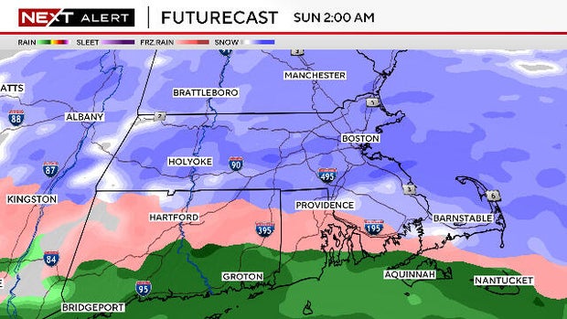
3 a.m. to 5 am.: Southeastern Mass. including most of Plymouth and Bristol counties and southern Worcester county (including the city of Worcester)
5 a.m. to 7 a.m.: Norfolk county, Boston area, Metro West, and areas along route 2 up through Worcester county
6 a.m. to 10 a.m.: the rest of northern Mass. including northern Middlesex and Essex counties, and then most of southern New Hampshire

How much ice will Massachusetts get?
Perhaps of greatest concern with this storm is the ice. Freezing rain will fall for several hours on Sunday near and west of I-495. We could see .10"-.25" of ice accretion on some tree limbs and power lines as well as your stairs and deck.
Travel on foot and by vehicle will be treacherous on any untreated surfaces.
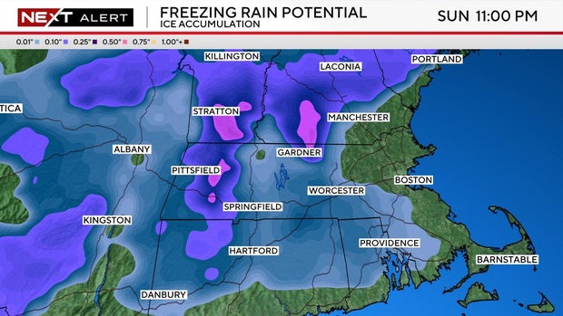
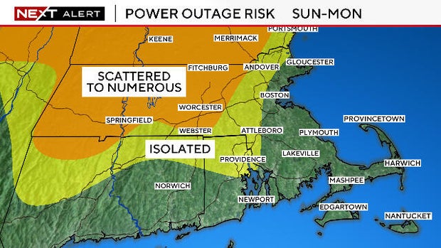
Power outages are a concern in areas with higher snowfall amounts topped with freezing rain. This will weigh heavily on trees and power lines in much of Worcester county, western Middlesex county and southern New Hampshire.
"Juicy" storm will have heavy freezing rain
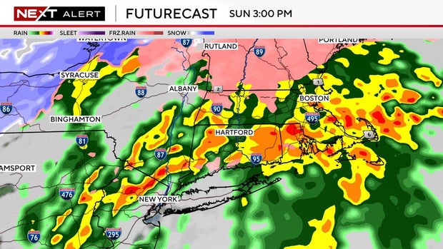
Part 3: Thunderstorms and flooding
This will be a very "juicy" storm, loaded with moisture.
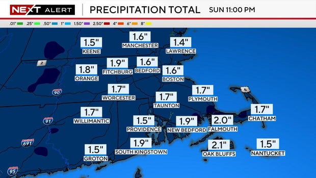
Total precipitation will range between 1.0"-2.0" in southern New England.
After a brief lull early in the afternoon on Sunday, there will be one final slug of heavy rain/freezing rain between 2 p.m. and 7 p.m.
This could include some embedded thunderstorms, especially over southeastern Mass. In addition, this will certainly lead to significant, localized street and urban flooding.
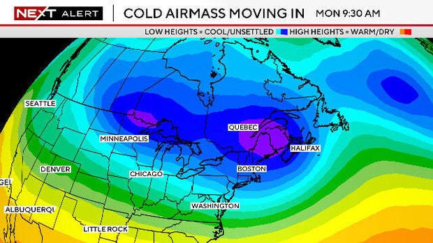
There will not be any melting post storm. Temperatures will be below freezing for most of next week. So, any snow or ice on your driveway Sunday night will not be going anywhere fast.
Part 4: The wind
The ice and rain will taper off Sunday night but there is still one final concern ...
As the storm departs it will rapidly deepen up near Nova Scotia. At the same time, a strong area of high pressure will be stationed over the Upper Midwest.
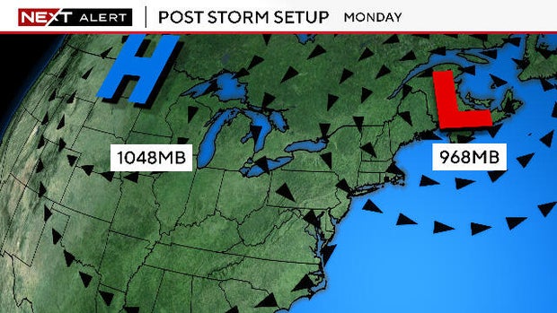
In-between the two, the winds are going to howl.
On Monday, there will be WNW gusts between 40-55 mph across all of New England.
On Tuesday, it will still be windy, but you can likely cut the Monday numbers in half.
This will undoubtedly lead to another round of downed trees and power lines and numerous power outages, particularly in those areas with ice and snow weighing down the limbs.
Secondarily, the winds will also drop feels-like temperatures to near or slightly below zero on Monday.
East Coast storm next week?
What's NEXT? The storm train keeps on rolling. We will be watching for a potential coastal storm later next week (Thursday-Friday timeframe). Too far off to tell whether this will be a hit or miss and what form it may take. As always, when we know, you will know.
For now, stay safe this weekend and stay tuned to WBZ-TV, CBS News Boston and WBZ.com.


