Snow returns to Boston area in 3 storms starting Wednesday. Weather forecast maps show what to expect.
Here is the very latest on the three separate systems expected to bring snow to Massachusetts in just the next 5 days.
We are expecting only minor impacts from the rain and snow Wednesday. Most towns will not need to plow.
Friday's storm for the Boston area is coming into greater focus and there is a high likelihood for plowable snow north of the Massachusetts Turnpike.
Confidence remains low and the stakes high for a potential nor'easter in Massachusetts on Monday.
Wednesday weather forecast
There will be a mix of rain and snow Wednesday afternoon without much impact or accumulation.
The rain will change to snow in most areas after dark but again, we don't anticipate much impact.
The snow will taper off between 10 p.m. and midnight.
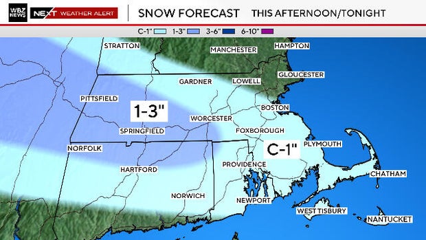
How much snow Wednesday?
Here's what you can expect:
A coating to 1 inch from the Route 2 area down through Boston and a good portion of Middlesex County. Also, all of southeastern Massachusetts including the Cape and Islands.
One to 3 inches for most of western Massachusetts and parts of southern Worcester County.
Temperatures will drop well below freezing late Wednesday night causing any untreated roads and walkways to become slippery where rain or snow fell.
Use caution when going out early Thursday.
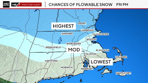
Friday snow forecast
The second storm coming Friday will be "juicier" than Wednesday's event and also will cover a much wider area (most of New England).
Therefore, we feel as though the overall impacts will be higher.
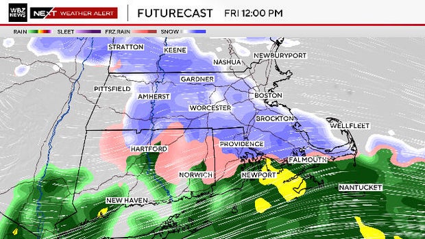
We expect a "front-end thump" of snow arriving late morning into midday Friday.
In other words, just about the entire area will start with a burst of snow with the possible exception of the far South Coast.
There will likely be some mixing with ice and rain south of Boston. It's still to be determined how far north the mixing line gets. Areas north of the Massachusetts Turnpike have the greatest chance of staying all snow and, therefore, also are likely to get the highest accumulation.
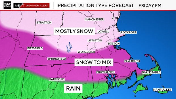
As is the case with many of our storms, temperatures will crash later in the event, and it will end as all snow late Friday night. We expect the steady snow to taper around or just after midnight.
How much snow Friday?
It's too early for specific numbers, but we feel pretty confident that the highest risk for plowable snow will be along and north of the Massachusetts Turnpike.
This will not be a major snowstorm. We envision something along the lines of 3-to-6 inches right now north of the Pike. We'll have more on this later Wednesday evening.
Third storm Monday
Last but not least, there will be a major storm forming off the Carolinas later this weekend. This one will really "bomb out" just offshore and become a powerful ocean storm on Monday.
The impacts here in Massachusetts are dependent upon the track of the low pressure.
This has been a common theme this winter. We have narrowly missed several storms that have tracked just a bit too far south of our area.
As of this writing, I would put the odds of a worst-case scenario at 1-in-4. Should this occur, we would have a major snowstorm on our hands, strong winds and also coastal concerns.
I would put a complete miss at the same odds, 1-in-4.
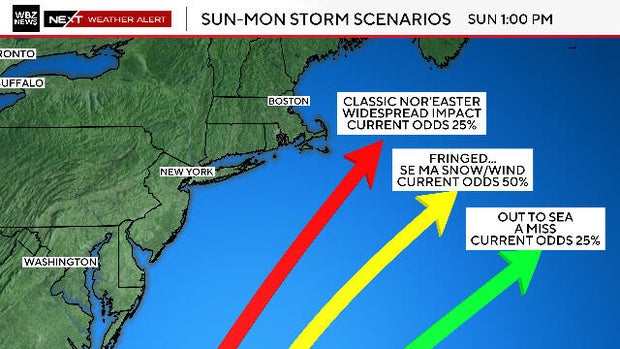
We are slightly leaning towards a middle track, a 1-in-2 chance. Our area would be fringed by the storm with the greatest impacts over southeastern Massachusetts .
The WBZ Weather Team will keep you updated every step of the way on WBZ-TV, CBS News Boston and WBZ.com