Record heat possible in Boston Friday, followed by severe thunderstorm threat. Map shows areas of highest risk.
Another round of high heat, oppressive humidity and potentially severe storms is coming to the Boston area and the WBZ-TV Weather team has highlighted Friday as a NEXT Weather Alert Day.
The National Weather Service has expanded the heat advisory, which will continue through 8 p.m. Friday.
Sitting about halfway through meteorological summer, we have already equaled the number of 90-degree days from 2024 in Boston.
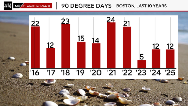
We will be adding on to that total in the next couple of days.
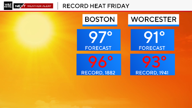
If you thought Thursday was hot, Friday will be another level. Temperatures will reach into the mid and upper 90s, challenging some daily records.
Dewpoints will top out near 70, adding 5-10 degrees to the "feels-like" temperature.
A cold front will sweep through Massachusetts Friday afternoon and evening ushering in some cooler and drier air.
Severe thunderstorms risk
Unfortunately, in order to get there, we will have to endure a round of thunderstorms, some of which could reach severe levels.
The Storms Prediction Center has placed portions of our entire area in a "slight" risk, or level 2. The SPC also has increased the risk of some damaging, straight-line winds Friday afternoon and evening, particularly from Worcester County and areas south-westward.
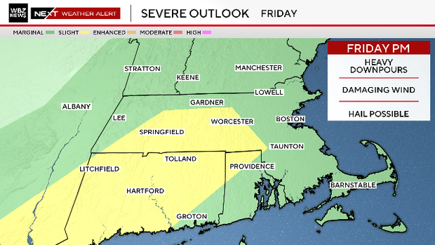
The highest risk for thunderstorms will be between 2 p.m. and 8 p.m. on Friday.
Most models currently favor areas along and south of the Mass Pike for the most storm coverage. This would certainly make for a long ride down towards the South Coast, Cape Cod and the Islands.
Any storms that form may contain very heavy downpours, lightning, damaging wind gusts and small hail. If you have outdoor plans Friday afternoon and evening, we urge that you stay tuned to updated forecasts.
Weekend weather forecast
After those storms pass, drier air flows in and we are in for another terrific Saturday!
Sunday may bring another risk of showers or storms but by no means do we expect a washout.