Winter weather advisory for North Texas is over, radar clearing before freeze returns overnight
NORTH TEXAS – The winter weather advisory for North Texas expired at 12 p.m. Friday as snow and sleet cleared out of the region. Early Friday morning, the originally issued winter storm warning was canceled and replaced with the advisory.
The NWS said that roads will improve throughout the day after hazardous conditions in the morning hours.
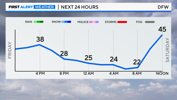
There will be cloudy skies on Friday afternoon, with the high temperature reaching 35 degrees and lows later in the day dipping into the teens and low 20s. Wind chills will make it feel even colder. Around 6 a.m., snow flurries were falling across the Dallas-Fort Worth Metroplex.
CBS News Texas meteorologists said to expect hazardous road conditions once again Saturday morning. Whatever precipition remains on the ground will freeze in the frigid temperatures overnight and could create black ice on the roads, according to the NWS.
Several North Texas school districts canceled classes on Thursday and Friday due to the weather and road conditions.
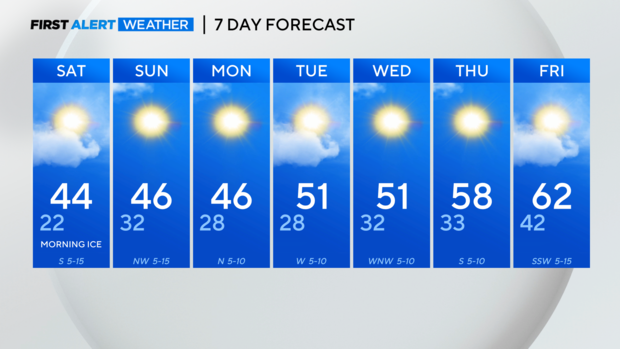
For the rest of the weekend and into next week, expect partly cloudy to clear skies with highs in the 40s.
Snowfall totals across Dallas-Fort Worth
Several inches of snow and sleet fell across North Texas on Thursday. As of Friday morning, here are snowfall totals:
- Knollwood – Grayson County: 11 inches
- Muenster – Cooke County: 8 inches
- Whitesboro – Grayson County: 7 inches
- Denison – Grayson County: 7.2 inches
- Nocona – Montague County: 6.3 inches
- Celina – Collin County: 6 inches
- Frisco – Collin County: 3.5 inches
- Allen – Collin County: 3 inches
- Keller – Tarrant County: 2.8 inches
- Dallas-Fort Worth International Airport – Dallas/Tarrant County: 2.6 inches
- Sachse – Dallas County: 2 inches
- Fort Worth – Tarrant County: 1.8 inches


