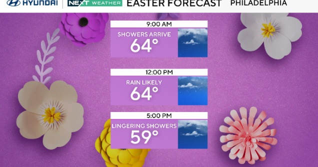
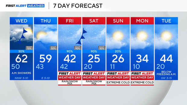
Temperatures in the 60s, some showers possible ahead of cold front that brings wintry mix to North Texas


First Alert Weather Days are in place beginning on Friday and continuing through Monday due to wintry precipitation and dangerously cold temperatures. By Sunday, wind chills may reach the single digits or even below zero. North Texas will be below freezing from Friday evening through midday Monday.
Gov. Greg Abbott directed the Texas Division of Emergency Management (TDEM) to activate state emergency response resources ahead of the potential winter weather impacts expected across the state beginning Thursday.
Before that happens, the forecast calls for some showers Tuesday night into early Wednesday. Then, above-average temperatures are expected into Thursday. Highs on Thursday will be close to 60°.
Even though it's still too early to discuss rain, sleet and ice totals, here's a current outlook of the next system: Friday will start with rain and cool temperatures in the upper 40s. By Friday afternoon, a cold front is expected to move in, bringing some wintry precipitation by the afternoon into Friday evening. This could impact the evening rush.
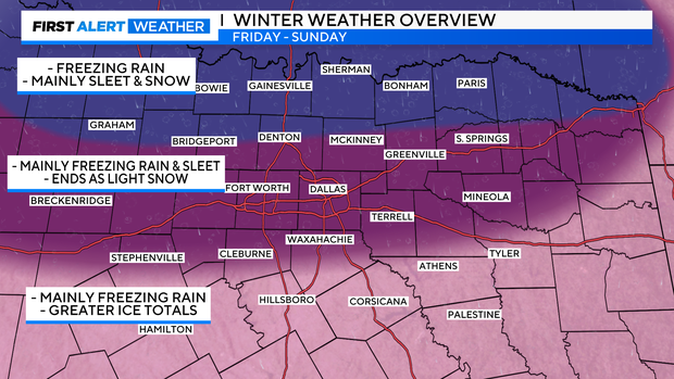
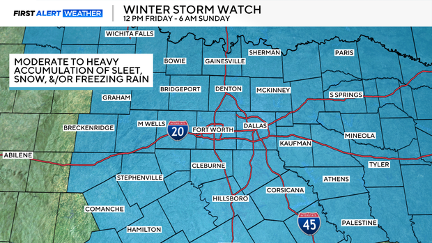
Winter storm watch in effect for North Texas Friday through Sunday
The confidence is increasing that moderate to heavy accumulation of sleet, freezing rain, and/or snow will lead to treacherous travel and potential power outages. Hence, a winter storm watch is in effect from 12 p.m. on Friday through 6 a.m. Sunday.
Temperatures will also be dangerously cold, and livestock and pipes are also at risk. Travel will be impacted significantly, and there is a threat of power outages. Now is the time to prepare.
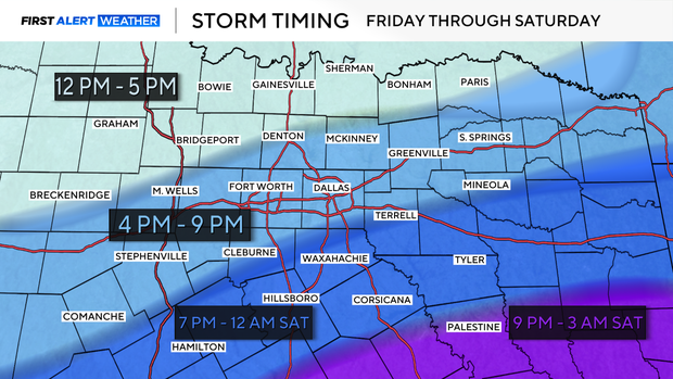
The timing of the frontal system and the temperature profile of the atmosphere will play a large role in what type and how much precipitation will fall. This forecast is still subject to change since it is a few days away, but as of now, the arrival of the wintry precipitation is highlighted below. The DFW metroplex could see impacts as early as 4 p.m. on Friday.
Temperatures will dip below freezing on Friday night and are expected to stay below freezing for up to 72+ hours. It is important to prepare now.
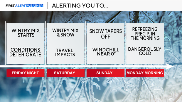
Friday night, conditions start to deteriorate. A wintry mix will move through the area and stick around through Saturday. By Saturday night, the wintry mix will likely transition to snowfall and taper off by the afternoon. Timing is still somewhat uncertain on what type of precipitation will fall at a particular time, but confidence is increasing.
The frigid arctic air settles into the forecast Sunday morning. The lows will be in the teens and single digits, but with a breeze, the feels-like temperature will be near zero. Dangerously cold mornings are expected on Sunday and Monday.
As of Tuesday night, a cold front will move across the area and bring the chance for some showers along and to the east of the I-35 corridor. No severe weather will be expected; the system is anticipated to push out of North Texas by the afternoon.
Wednesday and Thursday will be the time to prepare for this weekend's arctic blast. Be sure to turn off your sprinklers and protect your pipes, pets, and plants.
Stay tuned as the First Alert Weather Team continues to monitor the winter storm system.
Winter preparedness at home
When preparing for a winter storm, the National Weather Service recommends you have an emergency kit on hand stocked with:
- Non-perishable food
- Bottled water
- Extra blankets or sleeping bags
- Flashlight and extra batteries
- Battery-powered radio for important updates and emergency information
- First aid kit
NWS also recommends having an emergency heat source such as a fireplace or woodstove, adding to be sure to learn to properly use and ventilate to prevent a fire; have a fire extinguisher and know how to use it and make sure smoke detectors are operating by testing them regularly.
TxDOT and DPS winter driving tips
- Have a full tank of gas before you head out
- Be prepared to delay or cancel trips
- Allow extra time to reach your destination
- Avoid traveling when sleet, freezing rain or snow is predicted
- Slow down: speed limits are based on normal road and weather conditions, not winter road conditions
- Do not use cruise control
- Maintain at least three times the normal following distance on snow or ice
- Watch carefully for snow removal equipment and stay at least 200 feet behind snow plows
- Use extra caution on bridges, ramps, overpasses, and shaded areas as they tend to freeze first
- Watch for downed trees and powerlines
- If your vehicle starts to slide, ease off the gas pedal or brakes, steer into the direction of the skid until you have regained traction, then straighten your vehicle.
The Texas Department of Transportation said via X that crews will start pretreating roadways in Fort Worth on Wednesday ahead of possible winter weather.