North Texas get a break from rain before storm chances return overnight

The sun peeked out across North Texas following a stormy morning.
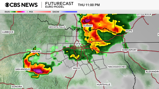
Heavy rain and hail, possibly up to the size of an egg, fell in western parts of the Dallas-Fort Worth Metroplex early Wednesday morning. The heavy rain will continue moving east as the day continues and there will be a break in storm activity by the afternoon hours.
The heavy rain will continue off and on into the afternoon hours with more storms developing overnight into Thursday.
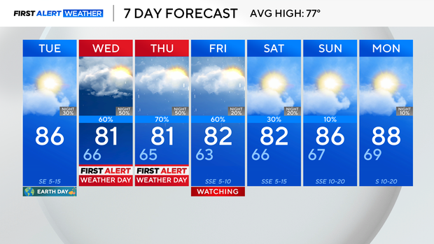
Temperatures will reach 79 degrees in North Texas on Wednesday.
CBS News Texas meteorologists have issued First Alert Weather Days for both Wednesday and Thursday due to the disruptive, rainy pattern.
As North Texans head into the second half of the week, the active weather pattern isn't going anywhere. North and Central Texas will remain in a warm, moist environment, which will keep thunderstorm chances in the forecast. The timing and coverage will stay somewhat uncertain.
There could be a few showers and storms as early as Friday morning, especially near the Red River, thanks to a disturbance sliding through southern Oklahoma. There's some uncertainty on how widespread that activity will be, but there's enough instability in the atmosphere for a few storms to turn strong or even marginally severe.
Most of North Texas should see dry weather Sunday into Monday but later on Monday, storm chances pick up again.
Tuesday's forecast will hinge on whether any leftover storm boundaries from Monday stick around. Then on Wednesday, a cold front sweeps through, likely bringing another round of rain and slightly cooler temps to finish out the week.