Rain possible for North Texas as heat advisory remains, Ross Fire still burns


A heat advisory remains in effect through Thursday evening for most of North Texas.
Temperatures remain very hot, but the combination of additional cloud cover and lighter winds is keeping the overall fire-weather threat lower than it has been on some recent days.
Rain chances for North Texas
Most of the earlier showers are fading, but the atmosphere remains unstable enough for a few isolated showers or thunderstorms through this afternoon and early evening.
Any storm that develops could produce brief, strong, gusty winds and lightning. Coverage will remain low, and most locations will stay dry. For ongoing wildfires, including the Ross Fire, Thursday's lighter winds are helpful.
We have a partial lunar eclipse happening Thursday evening and night that will be visible across North Texas.
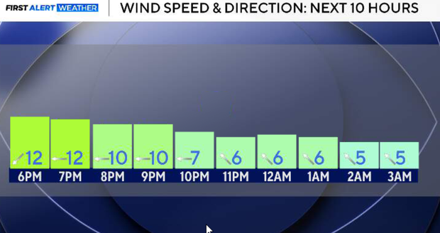
Quiet and dry conditions take over Thursday night. The surface wind will gradually turn from north/northeast Thursday evening to east/southeast toward daybreak Friday. That wind shift is worth monitoring around ongoing wildfires because it could change the direction smoke travels, although overall wind speeds are expected to remain light.

End of the week and weekend heat and rain chances for DFW
The upper-level ridge begins expanding back toward North Texas on Friday, shutting down our recent opportunities for thunderstorms.
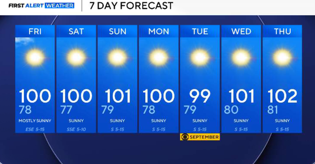
Temperatures will also climb another degree or two, with widespread highs around 100–102°. Humidity should decrease slightly, with heat index values generally in the lower 100s to around 106°. At this point, the National Weather Service is holding off on another heat advisory for Friday, although it will remain very hot.
High pressure becomes firmly established across the Southern and Central Plains this weekend. Subsidence (the gradual sinking or downward settling of the Earth's surface beneath the ridge) will bring mostly clear skies, very little opportunity for rain and continued triple-digit heat. Highs should generally remain in the lower 100s.
How hot will it be next week in North Texas?
Unfortunately, there is no meaningful pattern change showing up.
The ridge remains dominant through at least the middle of next week, keeping North Texas predominantly hot and dry. Highs remain in the lower 100s, while increasing humidity could push heat index values into the 105–108° range in some locations. Additional heat advisories may eventually be needed.