Heat advisory in effect for North Texas as front brings wind shift from Ross Fire; rain possible for some


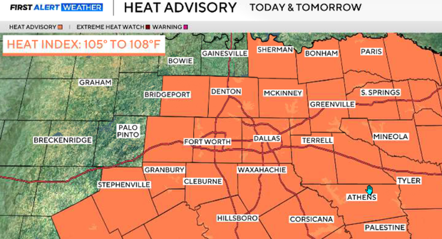
A heat advisory is in effect until Thursday at 8 p.m. across North Texas. While temperatures are coming down from the extreme 105°–109° heat of recent days, it will still be very hot. Highs will generally reach the upper 90s to low 100s, with heat index values near 105° in some locations.
A weak front is slowly moving south through North Texas Wednesday as an upper-level disturbance approaches from the northwest. The front will bring a 10–30% chance for showers and thunderstorms, mainly Wednesday afternoon and evening. Coverage will remain isolated, but a few storms could produce strong, gusty winds because of the relatively dry air near the surface.
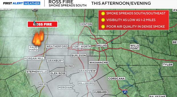
We're also closely watching the Ross Fire, which has now burned roughly 80,000 acres. Unfortunately, Wednesday's spotty rainfall is not expected to provide widespread or meaningful help to firefighters.
The overall fire-weather threat is lower on Wednesday thanks to more cloud cover and somewhat lower wind speeds. However, the frontal passage will cause an important wind shift from southwest to northwest, which could change the direction of fire and smoke movement. Smoke may also reduce visibility in areas near ongoing wildfires.
Scattered clouds will give way to some sunshine, allowing temperatures to climb into the upper 90s and low 100s on Wednesday evening. As the front moves through, isolated showers and thunderstorms may develop. The overall chance is only 10–30%, so most locations will stay dry.
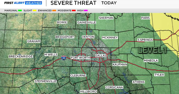
The greatest potential for a stronger storm is generally north and east of the metroplex. Any stronger cell could produce gusty winds, potentially 50–60 mph in isolated locations, along with lightning and brief heavy rain. Some of our counties, east and northeast of the metroplex, are under a level 1 threat of a gusty thunderstorm.
The front continues slowly south Wednesday night, taking the better rain chances with it. Northwest winds will develop behind the boundary, with lingering isolated showers or storms possible farther south.
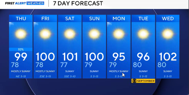
Thursday should be slightly cooler, with highs generally in the upper 90s to near 100°. Another disturbance moving around the upper ridge could produce additional isolated showers and thunderstorms, but coverage remains low. Most of North Texas will stay dry.
Friday and the weekend
Rain chances fade beginning Friday as the front washes out and high pressure starts building east into Texas again.
The good news is that this ridge does not appear as strong as the one responsible for our recent extreme heat. Highs should generally remain in the upper 90s to around 100° through the weekend and early next week. That's still above normal, but considerably better than the 105°–109° temperatures we recently experienced.
There is still no meaningful break from the overall hot and dry pattern. Long-range guidance continues to favor above-normal temperatures and below-normal rainfall into the first week of September.