After record-breaking weekend, North Texas faces another extreme heat warning for dangerous temperatures


Monday remains the peak of this latest heat stretch, but Tuesday will still bring another afternoon of extreme heat.
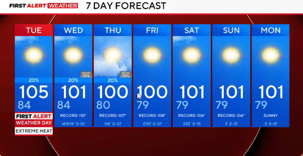
The upper-level ridge is beginning to shift west, but the air mass over North Texas remains exceptionally hot. Tuesday highs will generally range from 104° to 107°. A more noticeable change begins Wednesday as the ridge settles farther west and weak northerly flow develops overhead. Temperatures will ease several degrees, and occasional disturbances may finally bring low rain chances back into the forecast.
Dangerous temperatures for Dallas-Fort Worth
Dangerous, record-breaking heat continues through the rest of Monday.
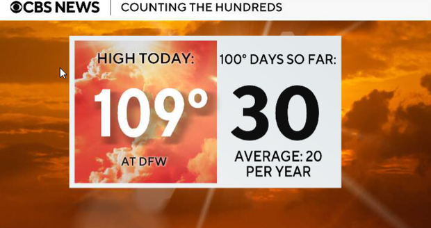
Highs across North Texas will reach roughly 105° to 109°, with DFW hitting 109°, which breaks the daily record of 107°.
South-southwest winds around 15–20 mph, afternoon relative humidity around 15–20%, and extremely dry vegetation will also keep the grass fire threat elevated, especially west of I-35. Temperatures will remain above 100° well into the evening before slowly falling after sunset.
Another very warm night is ahead. A disturbance moving around the northern edge of the ridge may bring additional clouds and a small chance for isolated showers or thunderstorms across northeastern North Texas late tonight into Tuesday morning. Coverage remains low, and most communities will stay dry.
Tuesday and Wednesday
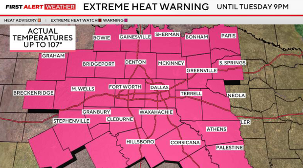
Tuesday is also a First Alert Weather Day. The extreme heat warning remains in effect through 9 p.m., with highs generally between 100° and 109°.
While temperatures may come down slightly compared with today, dangerous heat continues. A few showers or thunderstorms may be possible during the morning as a weak disturbance moves through, but widespread rainfall is not expected.
Wednesday is when we finally begin to notice a modest change. The upper ridge shifts farther west into the Desert Southwest, placing North Texas beneath weak northerly flow aloft. That should allow afternoon temperatures to drop into the upper 90s to low 100s, with DFW around 102°. Low rain chances will also continue as weak disturbances move through the region.
Weekend remains hot for North Texas with some rain chances
Temperatures remain hot, but generally below the extreme levels of Monday and Tuesday. Highs should range from the upper 90s to around 103°, with occasional low chances for showers and thunderstorms. These storms will remain hit-or-miss, and most communities will stay dry on any given day. Where storms develop, gusty winds, lightning and brief heavy rainfall will be possible.
The break from the most intense heat may be temporary. Forecast guidance suggests the ridge could begin expanding eastward again late this weekend into early next week. If that happens, temperatures will start climbing again while rain chances decrease. The prolonged hot and mostly dry pattern will continue to worsen drought conditions and maintain an elevated wildfire threat, especially in areas that miss out on rainfall.
Grass fire risks in North Texas
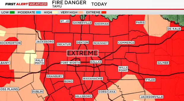
The National Weather Service is currently monitoring a handful of wildfires west of I-35. The largest at the moment is in central Palo Pinto County, near US-180 and FM 919.
After more than a month without measurable rainfall, finer surface fuels are becoming critically to extremely dry and are ready to burn.
Monday afternoon, sustained south/southwest winds of 10–15 mph, with occasional gusts of 20–25 mph, are combining with very low relative humidity of 18–25% to create an elevated fire threat, especially along and north of I-20 and west of I-35W through Monday evening. Breezy conditions could allow fires to spread quickly and become more resistant to control.
Winds should lighten somewhat Tuesday, but with poor overnight humidity recovery, critically to extremely dry fuels and above-average temperatures, the increased wildfire threat will continue Tuesday afternoon and evening.