Work week in North Texas starts hot and humid before rain brings a cold front

It was an active last 24 hours across North Texas, some reports include 72 mph winds and hail the size of hen eggs. This caused damage to a lot of folks across Collin and Denton County.
The next big front leading to severe weather and heavy rain is on the way. The First Alert Weather Team is tracking a cold front that will collide with an abundance of moisture and instability Tuesday evening into Wednesday morning. This will lead to a potential of severe weather and heavy rain, which could lead to flooding.
Severe weather threat returns Tuesday, Wednesday
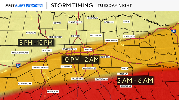
As of now, the Storm Prediction Center has highlighted a level 2 out of 5 threat across the northeastern counties and a level 1 out of 5 for isolated severe storms for the rest of North Texas. All modes of severe weather, such as large hail, damaging winds, flooding, and even an isolated tornado, will be a possibility.

Now is the time to prepare and have a safe place for family members and pets to move to in case severe weather hits your area.
Highs on Tuesday will skyrocket into the upper 90s with a heat index value in the triple-digits. During the day, sunshine will be present, but as the front moves through in the evening, storms will be present.
The good news is that Wednesday highs will be much cooler in the 80s. The mild fall weather will continue into the weekend, a perfect forecast to go to the State Fair.