Extreme heat warning extended across North Texas as temperature continue to sky rocket


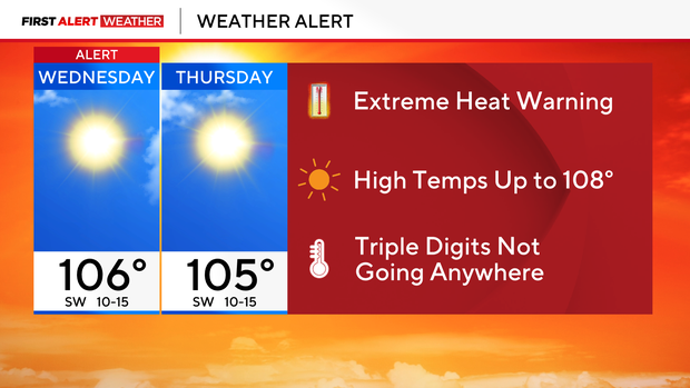
Wednesday and Thursday are First Alert Weather Days in North Texas due to an extreme heat warning. High temperatures will range from 100° to 108° across North Texas, with the hottest locations again reaching dangerous levels.
Both days' forecasts are also almost identical to Tuesday, including another extreme risk of fire danger.
High temperatures and lower humidity in DFW
Very hot conditions continue Wednesday and Thursday, with temperatures near or above 106° in many areas. Afternoon dew points will mix out, so heat index values will stay within a few degrees of the actual temperature.
Even with relatively lower humidity, these actual temperatures are dangerous, especially for anyone working or exercising outdoors. We're also watching a weak front that could bring a 10–20% chance for isolated thunderstorms Thursday afternoon and evening, mainly across northern and northeastern North Texas. Most locations will remain dry.
The continued heat and afternoon relative humidity of only 20–30% will also keep the risk of new grass fires elevated.
More hot and dangerous heat ahead
Expect mostly sunny skies and dangerous heat. Highs will range from 100° to 108°, with many North Texas communities reaching 105° or hotter.
The extreme heat warning remains in effect through the evening. Humidity will decrease during the afternoon, keeping the heat index fairly close to the actual temperature. That does not reduce the danger from prolonged exposure to temperatures this high. Winds remain relatively light, generally 10–15 mph or less, but the combination of extreme heat, low humidity and dry vegetation means grass fires can still start easily.
Another very warm night is expected, with temperatures only falling into the upper 70s and lower 80s.
Extreme heat warning and heat advisory continue
Thursday is also a First Alert Weather Day. The extreme heat warning and heat advisory continue through 8 p.m. with highs once again ranging from 100° to 108°.
A weak frontal boundary will move into northeastern North Texas during the afternoon. That may be enough to trigger a few isolated thunderstorms late in the day and into the evening, mainly across our northern and northeastern counties. Rain chances remain only 10–20%, so most communities will stay dry. Any storm that does develop could produce lightning and gusty winds.
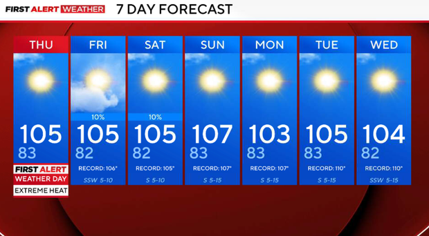
Temperatures remain in the triple digits this weekend, and most of North Texas stays dry. High pressure is expected to strengthen again over the weekend, keeping the hot pattern firmly in place.
There is still no significant break in the heat showing up in the extended forecast. Triple-digit temperatures continue into next week, and meaningful rainfall remains unlikely.