Cloudy, breezy to start week as severe storm chances increase across North Texas
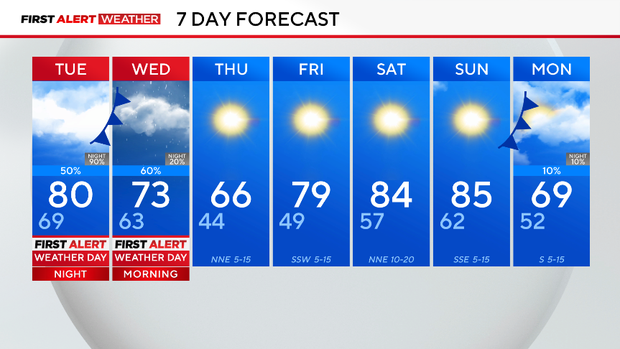
After a cool weekend, temperatures are right back to 80 degrees Monday and Tuesday. Expect brisk winds both days; these strong south winds are pushing up our humidity and priming the atmosphere for some stormy weather.
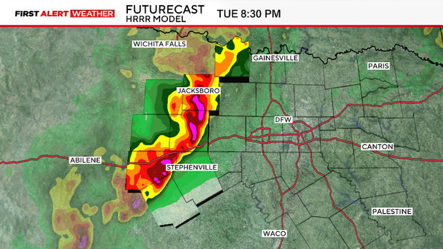
We expect some occasional morning showers Tuesday in the first half of the day. It'll be cloudy and windy, but the risk of severe weather won't arrive until later in the afternoon. There is a firm CAP in place, a layer of warm air just above the surface that suppresses thunderstorm activity. This CAP means the threat is isolated across the metroplex. But if and where that CAP breaks, a severe weather outbreak is possible.
Any cell that develops in the afternoon anywhere in North Texas will have to be monitored. The atmosphere will be unstable. All modes of severe weather are possible. Hail in size 2" or larger and 70 mph winds are possible. Strong tornadoes are possible as well if any cell can form ahead of the main line.
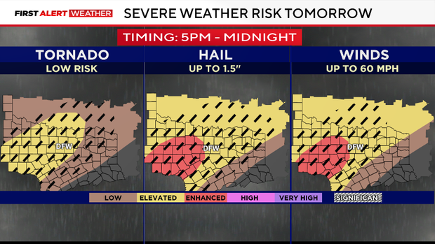
An approaching dryline from the west will increase that severe risk in our western counties. By early evening, we expect a squall line to develop.
When the squall line forms, the primary severe risk shifts to damaging winds along the leading edge of the storms. Quick-spin-up tornadoes along this edge could briefly form where the line bows out. This threat will move into the metroplex later that night.
After the leading edge comes through, the rest of the night and into the morning, we'll be more concerned with flash flooding. Several rounds of storms could move over our area during this time. Areas of heavy rain are possible during the morning commute on Wednesday.
There is yet another chance for storms in the afternoon on Wednesday as a surface low and cold front move directly over North Texas. These storms could produce small hail but are not expected to be severe. They could produce flood advisories; however, if they move over areas that saw heavy rain earlier that morning.
The First Alert Weather Team will be in place and monitoring the situation minute by minute. Once we get past the last round of rain on Wednesday afternoon, we are expecting dry and peaceful weather for the rest of the work week and the weekend. Another cold front that arrives on Sunday could produce a few showers, but not expected to bring a severe risk.