Wind advisory in effect for North Texas, prompting fire threat as temperatures rise into 70s


It has been a windy and warmer-than-average day across North Texas. In fact, the typical high for this time of the year is 63 degrees and 63 degrees was reached at 10 a.m. at DFW Airport this morning.
So far, this February is tied for the third-warmest February in history. The top warmest years were 2017 and 1976.
It has also been very windy; the peak wind gusts recorded so far at DFW Airport was 34 mph. A wind advisory will be in effect until 6 p.m. Tuesday.
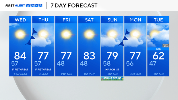
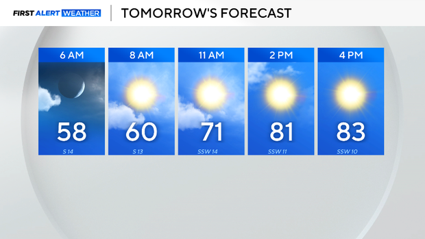
Tuesday night, winds will remain breezy, and temperatures will dip as soon as the sun sets at 6:21 p.m. Wednesday morning will be much warmer than the past few days, only getting into the 50s. Warmer-than-average temperatures will continue through the rest of the afternoon, eventually getting into the 80s.
The warmer than average temperatures, dry fuels and windy conditions will continue to lead to high fire danger through Thursday. Please avoid any activities that may cause a spark or a flame; any flame that ignites has the potential of spreading rapidly.
A cold front will cool temperatures a few degrees on Thursday, but warmer-than-average highs will stay in the forecast through the rest of this week and next. In fact, the Climate Prediction Center has high confidence that above-average temperatures are likely for the first two weeks of meteorological spring, starting March 1.
As for rainfall, conditions look to stay dry over the next 7 days, but there is another chance for some rain next week.