North Texas stays cloudy, breezy as chances of isolated strong to severe storms return by weekend

There are daily low chances for storms through the weekend, with Saturday the most likely day to see activity. Most areas stay dry, but any storm that develops could become strong to severe with hail and gusty winds. This is not a weekend to cancel plans; most areas will stay dry. Instead, it's a weekend to stay weather-aware, especially if you'll be outdoors at festivals or near the lakes like Grapevine Lake or Lake Lewisville.
End of the work week
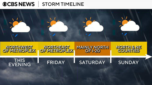
We are watching a very low chance (around 10%) of a storm developing late Thursday afternoon or evening, mainly across our far western and northwestern counties.
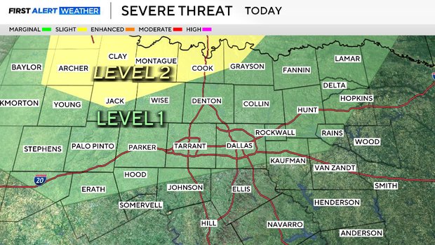
The atmosphere is capped right now, meaning a layer of warm air aloft is preventing storms from forming. That cap is expected to hold, so most areas will stay dry. However, if a storm is able to break through, it could quickly become strong, with the potential for large hail and gusty winds.
Low clouds will redevelop overnight, setting up another warm and somewhat muggy start to the day tomorrow. Expect lows in the upper 60s to about 70F.
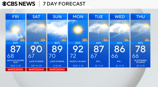
Friday will start quietly for most of North Texas, with a warm and increasingly humid airmass in place. Highs will climb into the mid to upper 80s, and with a southwest wind and a few breaks in the clouds late in the day, it will feel noticeably warmer.
By late afternoon into the evening, we'll be watching areas east and northeast of the metroplex for isolated storm development. This is a conditional setup, meaning storms are not guaranteed to form due to a cap in the atmosphere and limited large-scale lift. However, if a storm is able to develop, it could become strong to severe, with the potential for hail and gusty winds. Most areas will stay dry.
Storm chances this weekend
Saturday is the day we're watching most closely for storm chances.
The dryline to our west will help spark storms during the late afternoon and evening hours, with activity developing west and moving east toward North Texas. Coverage will still be limited, so this is not a washout, but any storms that develop could be strong, with hail and gusty winds being the primary threats. It will also be hot and humid, with highs in the upper 80s, and a few spots could approach 90 degrees.
Sunday, storm coverage drops back to more isolated levels, but the severe potential does not completely go away. We'll continue to watch areas near and north of the metroplex and eastward, where a few storms could develop during the late afternoon and evening. Any storm that forms could still produce gusty winds and hail.
Early next week
The pattern stays somewhat active early next week, with low daily storm chances continuing. At the same time, temperatures remain above normal, with highs in the upper 80s and possibly near 90 degrees in a few spots. A cold front could finally push through on Tuesday of next week, but the timing is still uncertain.