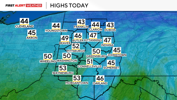
Today will be the pick of the week in the Pittsburgh area with high temperatures in the 50s

Today's weather will be the pick of the week for the Pittsburgh area with highs in the 50s.
Any Alert Days Ahead? It's tough to pinpoint just one day. We may get to a day and snow chances look high enough and the timing is there where a FAWD could be needed.
Aware: We've already recorded 20.7" of snow this year. That is 8.3 inches ahead of our 'average' pace.
At least the weather is going to be nice today. Maybe today is a day when you appreciate all the little things that make life special. Take your dogs for a nice walk. Take your lunch outside. Explore a road you've never been down before. I have highs hitting the low 50s today. Morning temperatures have dipped to around 30 degrees with wind chills in the mid to low 20s. I do have a chance for rain in the forecast but it is low and comes after sunset, with a cold front sliding through between 8 p.m. to 11 p.m.
If you see rain, it will not be a lot and won't last very long. Things will change behind the rain with wind speeds picking up and temperatures starting to tick down. Today will be the nicest day of the next week and a half, and there isn't even a close second day.
As we get into Wednesday, light rain showers will begin to move in for the back end of the morning commute. I have rain arriving after 8 a.m. in Pittsburgh, but before 10 a.m. Rain showers will continue for the rest of the morning into the afternoon before we see the rain chance turning to a snow chance. Temperatures will steadily drop all day long on Wednesday. Wednesday's high of 44 degrees will be hit at midnight tonight. Temperatures will be in the low 40s for the morning commute. Temperatures will be in the mid to upper 30s at lunch and into the low 30s by sundown. Our daily low temperature of around 27 degrees won't be hit until just before midnight Thursday.
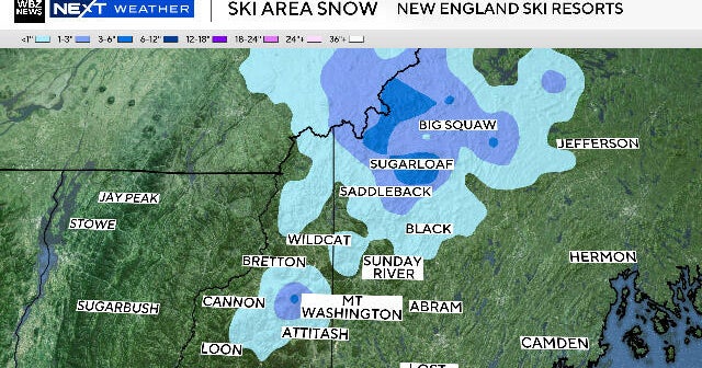
The rest of the week is looking snowy and cold. As of this morning, Pittsburgh has recorded 20.7 inches of snow. This is 8.3 inches ahead of our normal pace. We could easily add an additional 8 - 10 inches of snow to that total with the set-up that we have in place over the next week. At this point, there is no single day where snow totals stick out as being that much higher than others. If you're heading up to the ski resorts, it's going to be a fantastic stretch for skiing, with maybe upwards of 15 inches of snow falling over the next week. In Pittsburgh, snow totals of 8 - 10 inches will be possible over the next week. While that sounds like a lot, this snow will fall over a period of 6-8 days, limiting the short term impact.
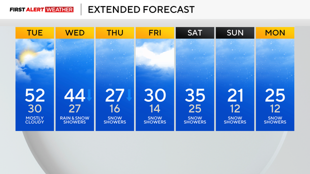
Looking ahead, the other big story is the cold air mass that will be in place next week for most of the week. We will have the chance to see several days with wake-up temperatures in single digits with wind chill values dipping below 0. The coldest of the air will be in place Monday through Thursday next week.
WEATHER LINKS:
Current Conditions | School Closings & Delays | Submit Your Weather Photos