Pittsburgh area to see rapidly falling temperatures, high winds and rain-to-snow over next 24 hours

Temperatures reached the lower 70s this afternoon, and winds are on the rise Sunday evening as a surface low pressure rapidly strengthens, moving from central Illinois into Michigan this evening.
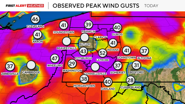
Several sensors across the Pittsburgh area are not reporting data from Friday's high wind event, but those that are reporting depict peak wind gusts so far this afternoon between 30 and 50 mph.
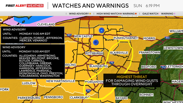
First Alert: Sunday night-Monday (High winds)
The National Weather Service has most of our counties in a wind advisory until 11 a.m. Monday. The greatest potential for significant wind gusts from now through the predawn hours of Monday will be in the Ridges, as these locations will have an elevation high enough to reach into the low-level jet, which will be very strong out of the south to southeast through the overnight hours.
Westward-facing slopes of the Ridges may receive downsloping, which will not only keep temperatures very warm through the overnight but also create a potential for damaging winds with gusts as high as 60 mph as well. Those in Fayette, Westmoreland, Indiana, and Preston counties should be on the lookout. Another area that high-resolution modeling suggests a potential for high winds through the overnight will be north of 422 toward Lake Erie with gusts between 45 and 55mph.
The Pittsburgh area should see gusts generally of 50 mph or less.
The cold front associated with this powerhouse surface low pressure has slowed just a hair, with frontal passage likely not occurring until between 9 a.m. and 2 p.m. Monday from west to east across our area.
Some rain showers are likely with the front, but the highest threat of severe storms still looks to stay well to our east once the front hits higher moisture values.
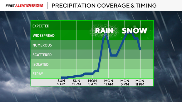
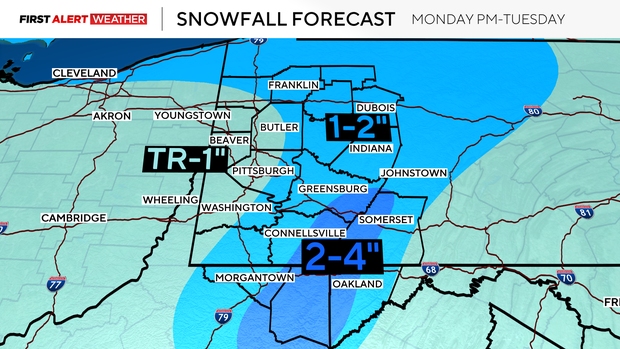
What has changed a bit for Monday is the increasing chance of snowfall during the late afternoon through late evening hours. This will be a window from 4 p.m. to 9 p.m., with areas generally from the I-70 corridor and points east into the Ridges most likely to see snow.
Given the warm ground temperatures, a lot of what we will see falling will melt on contact at first. However, strong upper-level dynamics will support a band of moderate to potentially heavy snowfall for a few hours tomorrow evening.
Accumulations for areas west of I-79 are likely to range from a trace to 1 inch, then 1-2 inches near and east of the Pittsburgh metro toward Route 119.
The greatest accumulations will be in the peaks of the Laurel Highlands and Ridges, with 2-4 inches possible.
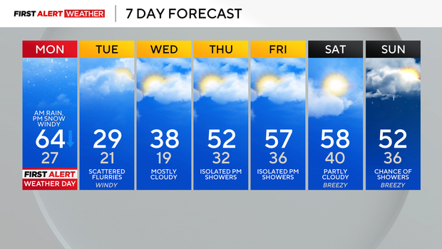
Lingering flurries, cloudy skies, and windy conditions are expected on Tuesday. Temperatures will struggle to reach 30 degrees for afternoon highs.
On Wednesday, winds will decrease as high pressure moves in. There will be at least three mini "shortwave" disturbances to traverse our region from Wednesday through Friday afternoon and evening.
These will reinforce cloud cover across our region, and the shortwaves on Thursday and Friday may induce some isolated showers. The air mass will overall warm, however, as low-level winds shift to the southwest. The next strong cold front will likely not arrive until next Sunday.