Pittsburgh in for a "dry" heat on Friday and Saturday

There's a lot to talk about heading into your weekend, so let's get started with what's most important to many out there, the weekend forecast.
WEATHER LINKS:
Current Conditions | School Closings & Delays | Submit Your Weather Photos
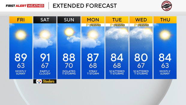
I have dry conditions both today and Saturday, with rain chances around on Sunday. Highs today will be in the upper 80s, and there is an outside chance that a community or two gets to 90 degrees.
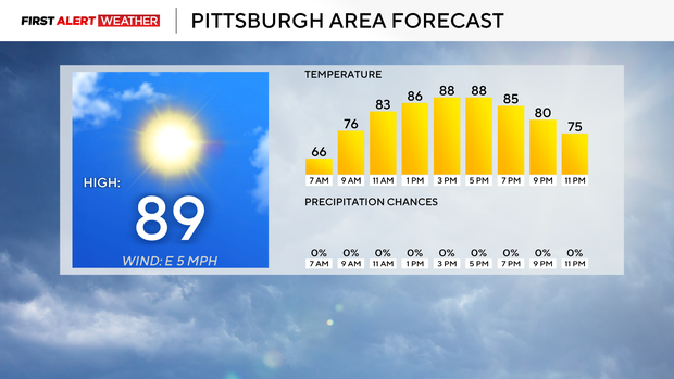
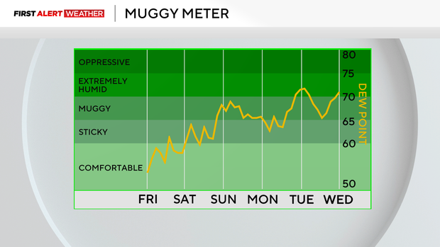
Humidity levels will be in the low range, with dew points in the low 60s. This means while hot, your comfort level won't be in the extreme range. Heat index values will be within a degree of the highs. Friday winds will be out of the north-northwest at around 5mph.
Saturday highs will be near 90 degrees. I have Pittsburgh hitting 91° for the high with humidity levels still low to moderate for the day. Skies should remain mostly sunny. There are a lot of activities going on Saturday, including a Steelers preseason game, Little Italy Days, and VegFest at the Allegheny Commons. If heading out, make sure you do the usual things to ensure your comfort, including lots of water.
Rain chances are back on Sunday.
Right now, moisture levels look to be near normal, and that should mean just isolated to maybe scattered showers should be expected throughout the day. Storm chances will be low, but I expect we will see a couple of storms rumbling through.
Sunday highs should be back in the upper 80s with the increase in cloud cover and rain chances. Morning lows will be near 70 degrees.
Yesterday, parts of our area were included in the weekly US Drought Monitor drought map. This is the first time since April that parts of the area have been included in their weekly drought maps. The Drought Monitor's maps come out every Thursday, but the data cut-off is on Tuesday morning.
I only have scattered rain chances in place both Sunday and Monday, with little consistent rain expected before the Tuesday cut-off. Our best rain chances for the next week come on Tuesday and Wednesday.
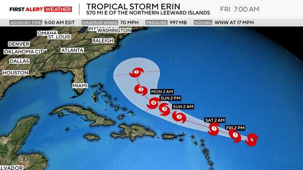
Finally, the Atlantic's first major hurricane is expected to develop this weekend and may happen by the end of today. At this point (6 a.m. Friday, August 15th), tropical storm Erin has sustained winds of 70mph and is just shy of hurricane intensity.
Stay up to date with the KDKA Mobile App – which you can download here!