It's going to be a sunny day in the Pittsburgh area with temperatures in the 40s

It's going to be a sunny day throughout the Pittsburgh area with temperatures in the 40s.
Any Alert Days Ahead? There's a chance for Wednesday to be a First Alert Weather Day. I'd put the overall chance as moderate to low.
Aware: Daylight Saving Time returns on Sunday
Sunshine and winds out of the southwest should help to warm us up to the low 40s todays. I only have noon temperatures near 30 degrees. Enjoy!
On Wednesday, a potent spring storm system is expected to slide by. The powerful low-pressure center is expected to move from the west to the east right through our area. We will briefly be in the 'warm sector' but most of the forcing will remain to our south. This should limit convective energy to be right at or just below what you'd expect for severe weather. We have been placed in the 'marginal' risk for Wednesday due to our expected set-up. Fast-moving storms bringing wind speeds of 58mph or higher are the biggest concern.
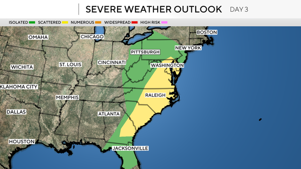
Wednesday's system will bring a couple of days of stormy weather to the United States. Today the storm chance will be focused on the center of Oklahoma stretching down to parts of Northern Texas. The bullseye switches to the Louisiana, Arkansas, and Mississippi on Tuesday. Tuesday will have the highest storm chance for the week for any one area with the highest tornado chances. Finally, on Wednesday the focus will be on places to our southeast from a sliver of Pennsylvania, Maryland, and Delaware extending to parts of Georgia.
The other big system will be a mid-level low expected to slide through on Saturday. This system shouldn't have any type of severe weather threat for us. Mostly rain should be expected with that system.
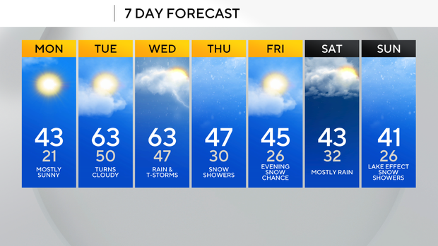
With brief snow chances late Friday and more snow expected late Saturday into Sunday due to snow showers coming off of Lake Erie.
WEATHER LINKS:
Current Conditions | School Closings & Delays | Submit Your Weather Photos