Pittsburgh Weather: Nor'easter storm effects bringing rain and snow to the area
PITTSBURGH (KDKA) - The dry stretch is unfortunately over.
The nor'easter storm is causing issues mainly for the East Coast, but we still feel some of the effects from it through Tuesday.
WEATHER LINKS:
Current Conditions | School Closings & Delays | Submit Your Weather Photos
Expect consistent rain showers with overcast skies today with breezy conditions and highs around 50°. Rain will last from the afternoon and eventually wrap up late evening. Most places will see between 0.25"- 0.5" of rainfall.
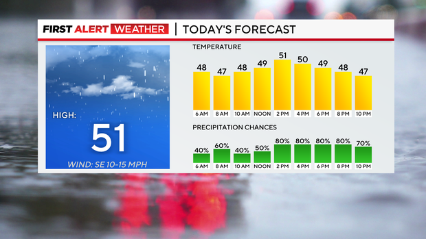
So grab the rain gear for any plans today!
Monday has been declared a First Alert Weather Day.
Winter storm watches are already in place for the ridges and laurels Monday afternoon through Tuesday morning since those areas could see several inches of snow. The day will start off with some light rain showers, but as the cold air rushes in midday, this will switch it over into snow showers. This will likely mess up travel making it slick and possibly slushy that evening.
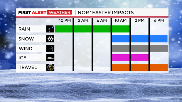
If you have to travel, it is best to do it in the morning or afternoon before it turns to snow. Gusts could approach 40 mph. Any loose outdoor Christmas decorations should be brought inside so they don't fly away! Also, temperatures will start in the 40s in the morning and then fall into the 30s by the afternoon.
Wind chills will likely be in the teens or 20s that evening.
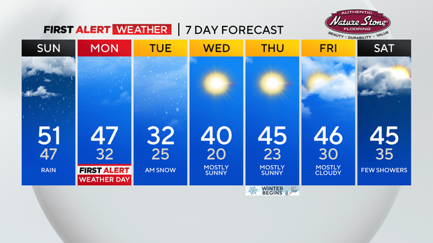
Scattered snow showers last through Tuesday morning as the nor 'easter pulls away from our region. Tuesday will be brutal with windy conditions and temperatures in the 30s.
So wind chills will be in the teens or 20s all day. In terms of snow amounts Monday into Tuesday, lower elevations including Pittsburgh could see up to 3" while the higher elevations could see between 3-6", isolated areas up there could see more than 6"!
More quiet weather returns by Wednesday with partly cloudy skies and lasts through Friday.
Highs will also be returning to normal in the low to mid-40s.
Thursday, December 21 marks the official start of the winter season as the solstice occurs at 10:27 p.m.
Also, it's safe to say now we are not going to see a white Christmas this year since temperatures are trending too warm to be suitable for snow.
Stay up to date with the KDKA Mobile App – which you can download here!


