A clear weather pattern will be moving into the Pittsburgh area for the next couple of days

A clear weather pattern will be moving into the Pittsburgh area for the next couple of days.
Skies are still mainly overcast this morning, especially from the Pennsylvania Turnpike and points southwest.
A few isolated showers are attempting to move northeast across Greene, Monongalia, and Washington counties around the circulation driven by an upper low across western Ohio. These will likely struggle to make it past I-70 however, as the low and mid level winds out of the northeast are bringing in drier air.
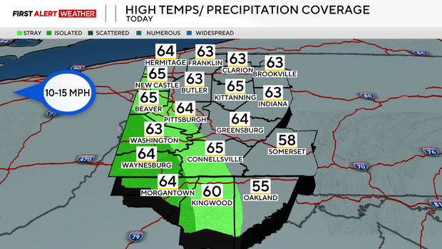
This will allow our northeast counties along the I-80 corridor to see some clearing today, and even some partial clearing as far southwest as the Pittsburgh metro area. Highs today will be in the low to mid 60s with lows overnight in the mid 40s to low 50s. On Thursday expect partly cloudy skies and an easterly wind around 10-15mph. The clouds will continue to thin out as surface high pressure noses in by Friday morning. The clearing skies accompanied by northeast flow at the surface will allow air temperatures to drop down into the low to mid 40s. By Friday afternoon, skies will be mostly sunny with temperatures in the upper 60s.
A strong coastal low will develop off the east Coast bringing rain and wind to parts of eastern Pennsylvania. We will be on the outer fringe of the circulation associated with that system, so while some clouds are likely, especially Sunday into Monday, dry northerly low level winds will keep rain chances very low.
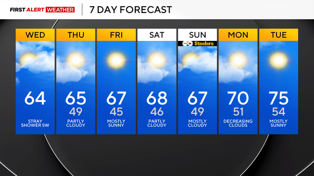
A ridge will build in by the middle to end of next week allowing temperatures to warm closer to and even above normal, but dry conditions will continue.


