Quick round of snow to hit western Pennsylvania Christmas Eve morning. Here's how much we could get.

PITTSBURGH (KDKA) — Monday started off with lows in the teens and single digits, but the Pittsburgh area will see a warm-up as the day goes on.
Monday, the area will have a little sunshine and then increasing clouds through late afternoon and evening. Highs will be seasonable right around 40 degrees.
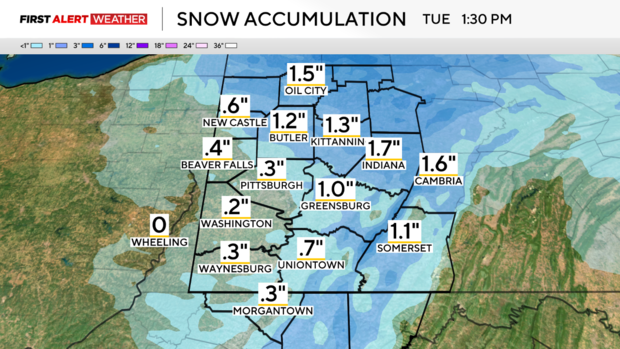
Overnight, a quick round of snow moves in, dropping about 1 to 2 inches mainly north of I-80 and in the Laurel Highlands. It starts a little before midnight and ends right around 5 a.m. Tuesday.
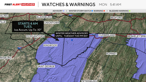
Garrett County, Maryland, is under a winter weather advisory from 4 a.m. to 7 p.m. for light accumulation, and 0.10 inches of ice accumulation is possible. Be careful traveling along I-68.
The rest of the week looks great for temperatures, making it to the low to mid-40s, which is above normal.
Pittsburgh's Christmas Day forecast
Christmas Day highs will be in the low 40s with partly cloudy skies. There is a small chance for a light mix/rain shower in the afternoon and evening but nothing measurable and it'll be very spotty.
Heading into the weekend, temperatures are back to the 50s with rain showers.