Dangerously low temperatures have arrived in the Pittsburgh area
Dangerously low temperatures have arrived in the Pittsburgh area with frigid air expected to be in place for the region through next week.
Any Alert Days Ahead? Today is a First Alert Weather Day due to the cold. There is the potential for First Alert Weather Days to be issued over the weekend and early next week due to both snow and temperatures.
Aware: The record low today is -18° set in 1985.
The cold has arrived and is every bit as cold as we thought it would be. Schools across the Pittsburgh area issued delays and closures in anticipation of temperatures with sub-zero wind chills.
For the past week, I have been consistent with a forecast of 4 degrees. We have already dipped to 3 degrees at the time of me writing this. I have Pittsburgh now, seeing a morning low of 2°. Wind chills are between -5° to -15°.
With temperatures as cold as they are, the NWS frostbite and wind chill chart shows that conditions like we are dealing with right now can cause frostbite to settle in as little as 30 minutes. Frostbite occurs due to your blood vessels constricting due to the cold. If the cold continues and water in your blood freezes, painful bruising can occur.
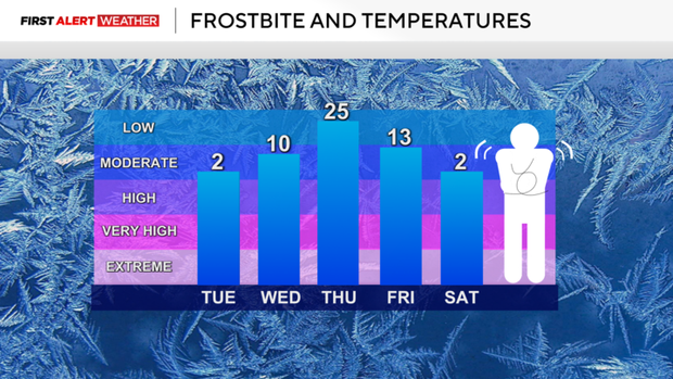
Prickly skin or even waxy-looking skin may be signs that you are dealing with frostbite.
The continued cold can also wreak havoc on your home, especially when it comes to keeping water flowing and pipes from bursting. A good rule of thumb right now, with how cold it is, is to locate your master water shut-off valve and make sure you can easily get to it. The last thing you want after a burst pipe, is the stress of finding or digging out the valve while two to five gallons of water per minute is rushing into your home.
Looking at your forecast, highs today will hit the mid to upper teens. Wind chills will top out at around 0°. It will be cold all day long, with temperatures dipping to around 10 degrees on Wednesday morning.
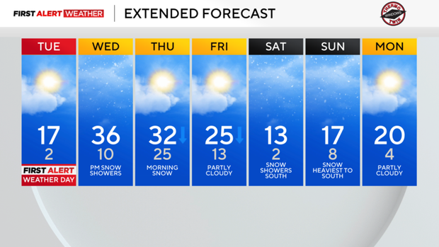
More cold temperatures are on the way, with morning lows expected to dip to the low single digits on Saturday and next Monday, too.
The Pittsburgh will have a snow chance Wednesday and another over the weekend
The other issue looking ahead are snow chances. The first snow chance is set to arrive on Wednesday afternoon, sticking around through Thursday morning. The 2nd snow chance arrives over the weekend, with big snow totals expected for places in West Virginia, Maryland, and Virginia.
For us here, the chance of getting a decent snowfall of more than three inches is possible, but not likely. The farther south you are, the higher the chance of seeing snow numbers above 3 inches. There are a couple of things that model data is struggling with when it comes to weekend snow chances. The main thing I am seeing is that model data is pushing our daily high on Saturday to the upper 30s, this should mean more in the way of rain for places south of us, but timing will be key to what everyone sees. I don't want to get too into the weeds right now on what to expect when there are numerous solutions on what 'may' happen.
Right now my advice for the weekend is to really monitor this system, especially if you are planning on traveling south.
WEATHER LINKS:
Current Conditions | School Closings & Delays | Submit Your Weather Photos