Cloudy skies are in today's forecast for the Pittsburgh area

It's going to be a cloudy day in the Pittsburgh area.
Any alert days ahead? None
Aware: Patchy fog will be around through around 9 a.m.
We will see cloudy skies today, due to the upper-level jet being parked just to our north.
There is some patchy fog out there to start the day. I have highs today hitting the mid-70s due to cloud cover. Noon temperatures will be near 70.
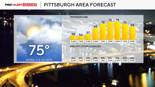
Rain chances will slide in this evening for places north of Cranberry, having the best chance at seeing showers overnight. This should be all rain with maybe a rumble or two. Rain totals along I-80 may hit two tenths of an inch, and rain should be done for our region by sunrise on Thursday. Thursday highs will be in the low 80s with sunny afternoon skies.
Friday is really the only good chance for rain over the next week in Pittsburgh. I have rain chances in pace from 8 a.m. through 7 p.m., so rain should be out of here by Friday Night Lights. Friday highs will hit the low 70s, with most of the day seeing temperatures holding steady in the low 70s or dropping. Expect it to be windy for the evening hours as temperatures drop fairly quickly, with us seeing a midnight temperature in the mid to low 50s.
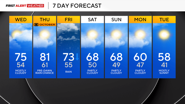
Your weekend is looking dry and fall-like, with highs both on Saturday and Sunday in the upper 60s and lows near 50 degrees. Just a heads up that some places along I-80 next week will likely see their first frost of the season on Tuesday of next week.
Pittsburgh is one of the cloudiest U.S. cities
While the city sees plenty of sunshine, especially in the spring and summer months, in my opinion, fall months and even the winter season can bring with them stretches of cloudy days. This is due to our region being perfectly located to see temperature inversions.
Temperature inversions occur when cool air is trapped at the surface with warmer air on top. You also need some moisture. We have all of this in place due to our topography with a big assist from Lake Erie. Inversions, when not caught, can mean a forecast several degrees under what was forecast. Skies that were meant to be sunny are instead cloudy. The strongest inversions can also bring light rain showers that linger through the day.
So why do we see inversions more here than most places across the U.S.? Let's compare our topography and setup with another city known for cloudy weather due to temperature inversions, Seattle, Washington. Seattle sits along the coast with cold water to their west and northwest. They have mountains to the east and an upslope with height increasing the further east you go. While they have a larger water source, Pittsburgh and our region have Lake Erie as our moisture source. We have a notable upslope from the lake into the Ridges and Laurel Highlands. So our topography checks out.
Inversions occur when winds are blowing in from the northwest, picking up moisture from Lake Erie. As the moisture-rich air cools and reaches saturation, it must lose the extra moisture it is holding, creating clouds. The now dry and cooling air becomes trapped below more buoyant, warmer, and humid air, giving us a cloudy day. Inversions are not always picked up by model data, so it is something we meteorologists have to keep a close eye on. Yesterday was a perfect example of an inversion having an impact on the weather, with highs yesterday slightly below what we were expecting. Some data did pick up on the inversion late.


