It's going to be a cloudy day in the Pittsburgh area

It's going to be a cloudy day in the Pittsburgh area, on account of the nor'easter storm moving across the eastern coast of the United States.
Any alert days ahead? Solid chance one of our weekend days will be a First Alert Weather Day. Right now it looks like Saturday.
Aware: Indiana yesterday recorded a tenth of an inch of rain due to the storm sitting along the East Coast
Call it what you want, the surface low that caused flooding all up and down the East Coast (from the Carolinas off to the north at least) continues to churn this morning with the center of the system sitting around 45 miles east of Atlantic City, New Jersey. Flooding is continuing for places north of the center, with water levels lower than normal for communities to the south of the center of rotation. On top of the coastal flooding occurring in parts of New Jersey, we have also seen fairly widespread rain totals of four to five inches, with big rain totals extending as far inland as Winslow and Southampton. This double whammy just exacerbates flooding that is ongoing, as you have all that rainwater falling inland with strong wind slowing the natural drainage. The good news for these communities is that things will change quickly this morning as the storm picks up forward speed, moving to the north and putting the hardest-hit areas in a zone where winds will pull water out into the Atlantic instead of trapping the water inland.
For us, we saw some rain from the outer bands and the association of the system as far west as Indiana County and the Ridges of Westmoreland County. The city of Indiana recorded a tenth of an inch of rain due to the outermost band causing a lift. I place a 20% chance for showers today across our area due to the low chance for a passing shower or two. The chance for anyone to see some rain from the coastal storm continues to be low.
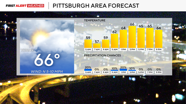
While you likely won't see any rain from the coastal storm, the storm is having an impact, with our general wind pattern being under the influence of the massive spin. Our mid-level winds are coming in from the east-northeast, and any rain we see would be moving to the west. Our surface winds are coming in from the north and will be between 5 and 10 mph for the majority of the day.
Clouds from the coastal storm will also limit our highs today. Yesterday we hit 72 for the daily high, with highs today only hitting the mid- to upper 60s. I have Pittsburgh seeing a high temperature of 66°. The storm moving to the north will allow us to get in a more normal pattern for the remainder of the workweek, with highs back in the 70s Tuesday and Wednesday. I have us hitting the 80s on Thursday, with rain chances ticking up for the weekend. I have weekend highs in the 60s.
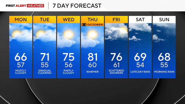
When it comes to lows, the coolest mornings of the week will come on Tuesday morning, where I drop us down to 55° for the morning low. I also have us at 54° for a morning low on Saturday.


