Sunshine will return to the forecast this afternoon for the Pittsburgh area

Sunshine will return to the forecast this afternoon for the Pittsburgh area.
Any alert days ahead? There's a low chance one of our weekend days will be a First Alert Weather Day.
Aware: Drizzle was enough for the Pittsburgh airport to record 0.01" of rain yesterday. All other measured rain occurred over in the Laurel Highlands and Ridges. Connellsville recorded 0.02" of rain.
Sunshine will return this afternoon, with it cloudy and drizzly again this morning. There will be some fog out there too. Morning temperatures are in the 50s with us seeing highs today hitting the low 70s. I have everyone cloudy through 9 a.m. I have places from the city of Butler to the northwest as sunny after 9 a.m. for the rest of the day. If you are in Pittsburgh skies will remain mostly cloudy from 9 a.m. through noon.
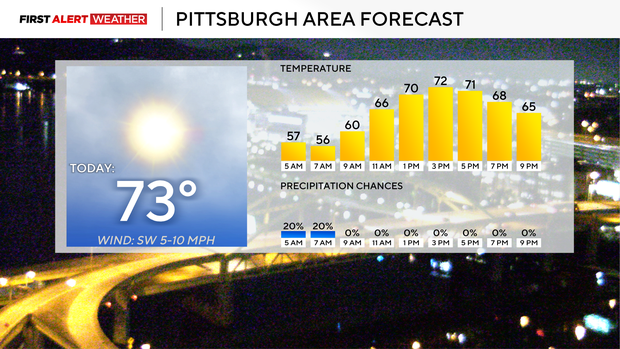
Skies will be partly cloudy from noon through 3ish and then mostly sunny after that. Winds will be light and out of the northwest. I have noon temperatures in the upper 60s and our high of 72° hit around 3 p.m.
Wednesday highs should hit the upper 70s with morning lows in the mid-50s. Highs on Thursday will hit the low 80s. Thursday lows will be near 60 degrees. Pittsburgh's highest rain chance for the week currently is on Friday, with rain rolling in just after the morning rush, so at this point kids walking into school should just miss the rain. Friday highs will be in the upper 70s for highs with cooler weather moving in for the weekend.
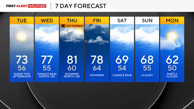
I have highs on Saturday and Sunday just in the upper 60s.
Rain could return this weekend
Confidence in model data over the next couple of days will be low as we will have two chances for rain to roll through. The first round could arrive as early as tomorrow night for places along I-80, with the line of showers stalling out along I-80. The secondard round of rain would impact us this weekend, but there is no guarantee that it makes it this far north and will depend on the strength of a ridge of high pressure that is currently centered over Memphis, TN.
The area that we will be watching for our potential rain on Wednesday and Thursday will be the line of moisture on the ridge's western side. Radar is showing showers extending from Arizona through Minnesota and up in to Canada all the way as north as Moosonee, Ontario. This line will move our way over the next 24 hours. The northern edge could bring light rain our way by Wednesday afternoon. Depending on timing, this line could also have an impact on the Steelers Thursday night game up in Cleveland with rain showers being possible. I have an isolated rain chance on Wednesday and a scattered rain chance for our northern communities on Thursday afternoon. While confidence remains low, I would say to expect some rain to occur at the Steelers game.
The next system is a bit further away, occurring on Saturday and there isn't as much data available on the potential track at this time. The GFS model shows some fairly heavy rain being possible from Allegheny County to the southeast. Rain totals could be more than an inch in spots, and maybe just enough to set off flash flooding concerns for an isolated spot or two. The EURO weakens the ridge enough to keep the area of low pressure and the accompanying rain well to our south.


