Dry weather in the Pittsburgh area could stretch into late next week

A stretch of dry weather in the Pittsburgh area could continue into late next week.
Any alert days ahead? None
Aware: Current yearly rain is at 38.64". This is just 0.97" shy of the average yearly rain total for Pittsburgh.
The day will start off with some cloud cover due to a tongue of moisture extending to the southeast into the Atlantic Ocean, where there is a broad area of low pressure in place at this time. That area of low pressure will bring coastal showers this weekend and high tide levels. It's not a tropical system, but it will cause some coastal flooding. If you saw a brief shower Wednesday afternoon, that moisture was the cause. The showers associated with the system are moving to the west, something we don't see too often here. The showers ended yesterday, but cloud cover from this system will stick around through at least 8 a.m., with some seeing mostly cloudy skies through noon. The afternoon is expected to be sunny and pleasant. We should see a sunny stretch through at least Saturday, with clouds back on Sunday.
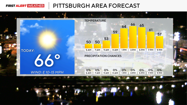
Yesterday's highs hit the upper 60s, which was well above where I had us on Tuesday. While the atmosphere is cooling, I am going to be fairly aggressive with my highs today, forecasting a high of 66 in Pittsburgh. This is well above guidance, but this time of year is notorious for model guidance not being aggressive enough, as we are in the middle of the 'do you use a fall or a summer' formula to calculate highs. I will put the noon temperature in the low 60s, with breezy winds coming in from the east at around 10 mph for the day.
I have temperatures back in the 70s for highs both Friday and Saturday. Morning lows will be cool, though, with lows dipping down to 45 degrees on Friday morning. Do we see frost advisories in the Laurel Highlands? I have Sunday highs near 70 degrees, and it will likely be cloudy for the Steelers game, along with the Great Race. There could be some fog around on Sunday morning.
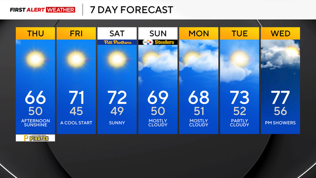
Looking ahead, we will be warmer and near average to start next week's workweek, with highs in the mid to low 70s for most of the week. Rain chances return next Wednesday and Thursday.
Wednesday was the brightest day this month since Sep. 7
I imagine folks out there yesterday were staring up at the sky yelling things like, 'What is this gold disc in the sky?' The instant the sun came out, I am sure Shumway was tracking an odd occurrence of accidents across the region. Sales of sunglasses likely went up across all of KD-country as people reached for anything and everything to protect their eyes from the onslaught of brightness that we hadn't seen since at least *checks notes* the 7th of this month. Seriously, we do actually record sky cover every day using a tool called a ceilometer. If your thought was lasers
If you were thinking lasers are somehow involved in recording sky cover, you'd be right. According to the NWS, the ASOS standard cloud sensor uses bursts of lasers occurring every few seconds to measure what, if any, cloud cover is happening. Similar to radar, the sensor is able to record the scatter, or reflection of light, coming back to the sensor to measure both the height and the thickness of clouds passing by. Unlike radar, the sensor detects light. There are limitations to what the sensor detects, and its data quality is assessed with the use of other resources, including but not limited to satellite data. While there are a number of nuances to how the data is received and categorized, at the end of the day, data gathered from the device is used to average 48 half-hour 'scores' given from 0-10. 0-4 is considered clear. 5-7 is considered partly cloudy. 8-10 is considered cloudy. Currently, we have seen 15 partly cloudy days this month. That's a little surprising, right? Five days have been considered cloudy, with two days considered 'sunny'. I am still waiting on Wednesday's data to come down as of 3 a.m.


