Mild and dry conditions expected to continue into the weekend for the Pittsburgh area

Mild and dry conditions throughout the Pittsburgh area are expected to continue into the weekend.
Expect widespread frost this morning thanks to clear skies and light winds in place. Some areas of river valley fog are possible closer to daybreak, but that fog will mix out as the morning progresses and the atmosphere starts to mix for the day. We can't also rule out some minor air quality issues too with high levels of pollution lingering near the ground, especially in and southeast of the Pittsburgh area due to a temperature inversion in place. The temperature inversion that we have in place explains why some areas are in the 20s this morning while others are in the 40s to almost 50 degrees. The lower in elevation your particular location is—the more likely you are to be below freezing.
Strong high pressure will continue to drive the large scale weather pattern today and through the upcoming weekend. Highs will reach the low to mid 60s during the afternoon with lows generally in the low-mid 30s with perhaps a few waves of mid to high level clouds. The next front we're going to watch will come in Sunday night into Monday morning. The amount of atmospheric moisture will be limited so at best—there will be some light rain and areas of drizzle. The temperature drop will be more impressive than the precipitation with this boundary. Highs will go from the mid-60s on Sunday to the lower 40s on Tuesday. Lows next week will be chilly as well in the upper 20s to low 30s.
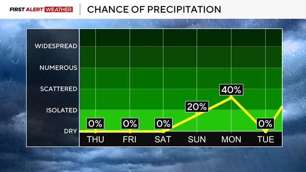
Looking ahead, models are in fairly decent agreement that a wave of low pressure will develop across the Plains States into the Mississippi River Valley Tuesday into Wednesday, then head our way late Wednesday into Thursday. The strength of this system and any precipitation in might bring will highly depend on the configuration of two branches of the jet stream. If the northern and southern branch of the jet stream interact or phase into this trough, then that will lead to a stronger system that could potentially bring more widespread and heavy precipitation and wind around Thanksgiving.
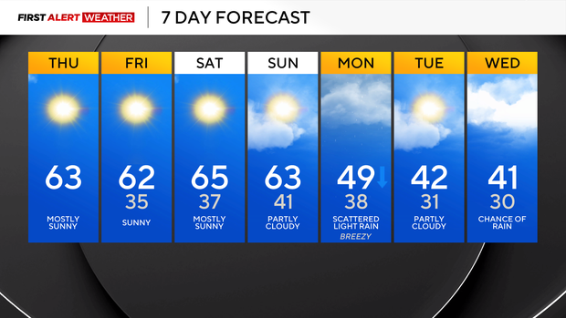
If these branches of the jet stream don't phase, then a less impactful system will pass through. We're still several days out and monitoring for trends in the pattern.