Map shows how much snow the Pittsburgh area could get this weekend with winter storm warning issued
A winter storm system is making its way to western Pennsylvania and is expected to bring significant snowfall to the region this weekend.
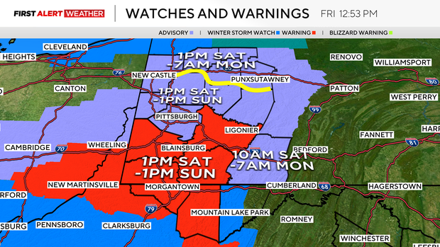
The National Weather Service issued a winter storm warning for parts of the Pittsburgh area along and south of Interstate 70 for Saturday into Sunday "due to a band of heavier snow."
The winter storm warning that goes into effect Saturday at 1 p.m. includes southwestern and western Pennsylvania, parts of eastern Ohio, and northern West Virginia. The watch runs through 1 p.m. Sunday.
Meanwhile, the rest of the area is under a winter weather advisory.
Snow totals could shift north or south depending on the track of the storm, but the National Weather Service said heavy snowfall could potentially exceed 6 inches for some parts of the area.
The National Weather Service said to plan on slippery road conditions. Travel should be limited during the evening hours of Saturday into Sunday morning, especially between the hours of 5 p.m. and 9 p.m., when rates will be heaviest and visibility the lowest.
How much snow will western Pennsylvania get?
Nearly all of the Pittsburgh area is expected to see between two and four inches of snow.
The current estimates forecast 3 to 5 inches of snow for much of the area, including Pittsburgh, and 5 to 10 inches for the ridges.
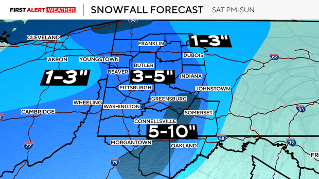
Some isolated higher amounts may occur toward the I-80 corridor by Sunday afternoon and night as the lake-effect bands develop in those areas.
Road crews ready but encourage people to stay home
Road crews say they're prepared for the snowfall. In Allegheny County, they have two dozen trucks and more than 9,000 tons of salt ready to go.
However, officials are encouraging people to stay home. If you don't have to go out, stay off the roads. They say it gives them room to do their jobs.