It's going to be another cool autumn day in the Pittsburgh area

It's going to be another cool autumn day in the Pittsburgh area.
Any alert days ahead? Potential on Sunday as tropical moisture rolls through
Aware: Some communities are under a frost advisory this morning. Some communities not under the advisory should be like Venango, Lawrence, Mercer and Butler.
How perfect has our recent stretch of weather been? Yesterday saw high temperatures hitting the mid-60s with crisp fall air in place. Morning lows were in the mid-40s. Today will be similar, with another autumnal morning giving way to plenty of sunshine and highs hitting the mid-60s. Temperatures will likely be just a degree or two cooler than yesterday.
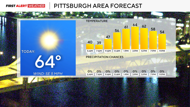
Getting right into the forecast, we will see a dry warm front, followed by what is likely to be a dry cool front, move through our area on Wednesday into Thursday morning. Temperatures will bump up into the 70s for highs on Wednesday. Thursday highs will be near 70 degrees, but probably a couple of degrees cooler than Wednesday. Friday will briefly see a return of highs in just the 60s.
When it comes to morning lows, today will likely be the coolest morning of the next week, with us being close to as chilly as Wednesday morning. Friday and Saturday will also see morning lows in the 40s and some upper 30s.
While I can't guarantee everyone will be dry on Wednesday into Thursday, most will. A weak cool front will likely move through dry, with maybe some sprinkles in some spots up along I-80. Besides that, our next rain chance comes on Sunday into Monday with the remnants of a tropical system that hasn't formed yet being the catalyst for rain.
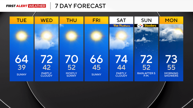
Model data has been consistent on this broad area of low pressure impacting us early next week. If so, big rain totals would certainly be possible. We will keep an eye on it.
This season's lack of hurricanes and what it tell us about winter
With everyone's attention returning to the Atlantic Basin, we should talk about the lack of storms in the Atlantic and what that may or may not mean for us. Currently, we have seen 0 Atlantic hurricanes so far this season, with around 3 weeks left in hurricane season. We have only ever seen two seasons with 2 or fewer hurricanes in the Atlantic since satellite data became a thing. That happened 80 years ago. So looking at that data, one of the following winters (1982) was a middle-of-the-pack winter with thirty inches of snow. The other winter, 2013, saw 63.4" of snow. That is the 8th snowiest over the past 80 years, so 90th percentile with snow.
Further cross-referencing with El Niño years, 1982 is listed as a weak El Niño year. 2013 is not listed as an El Niño year, but a strong El Niño occurred from 1014 through 2016. El Niño is known to suppress Atlantic Basin tropical storm formation, so there could be some correlation in lack of Atlantic storms versus snow output, but that is likely due to the prevailing global wind pattern known as El Niño.


