It's going to be a warm Pittsburgh-area weekend, but cooler temperatures will arrive next week

It's going to be a warm Pittsburgh-area weekend, but cooler temperatures will arrive next week.
Skies are clear with light winds across all of Western PA this morning as high pressure continues to dominate our large-scale weather pattern. Some rural areas and low-elevation zones are near freezing this morning, but most sites a running a few degrees warmer now compared to this time yesterday. Patchy frost and valley fog are also in place and there are some air quality issues southeast of Downtown Pittsburgh around the Elizabeth and Clairton areas due to high levels of pollution trapped beneath a temperature inversion.
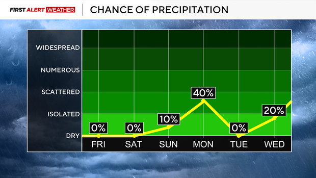
That inversion will mix out later today and with a dry air mass in place, temperatures will quickly warm up this afternoon with most areas reaching the low to mid 60s. Another clear night is expected with lows generally in the mid 30s. Even warmer conditions are expected on Saturday as southeast winds increase slightly. Highs will reach the mid-60s which is more than 15 degrees above normal. Mid and high level clouds will spread in from the south late in the day into Sunday morning from a coastal low moving up the East Coast. This will likely not impact our forecast area other than elevated levels of clouds, especially east and south of Pittsburgh on Sunday.
A weak disturbance and its associated cold front will move in from the Midwest States Sunday night into Monday morning. There will not be much moisture with the front, so at best, some light rain is expected Monday morning into Monday midday. The more noticeable impact from the front will be a chillier air mass to move in. Monday will likely see temperatures top out in the upper 40s then fall slowly through the day into the evening hours. The seasonably cooler air will linger around through Wednesday into Thanksgiving ahead of another approaching low from the Midwest states.
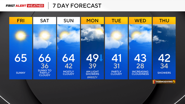
Looking at the large scale evolution of this pattern, this system will likely bring some rain to the region as the core of the coldest air mass will be moving out of the region in response to warm air moving in ahead of the approaching low. That being said, areas of higher terrain and locations where cold air is slower to retreat could see some wintry precipitation at the onset of the system late Wednesday into Thursday. We are still a week out from this system and at this point only able to diagnose broad elements with it, so be cautious if you are seeing outrageous social media posts with large snow and ice amounts with little context of the setup this far in advance.