Damp in the afternoon, another freezing rain chance Saturday

PITTSBURGH (KDKA) - Any Alert Days Ahead? Yes. FAWD in place through the morning shows. Another in place for Saturday, with a brief round of freezing rain expected.
Aware: Conditions more in line with what you'd expect for winter expected to return next week.
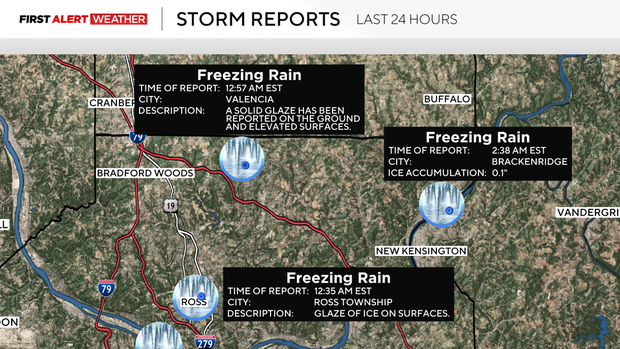
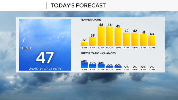
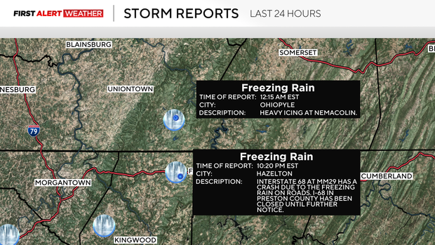
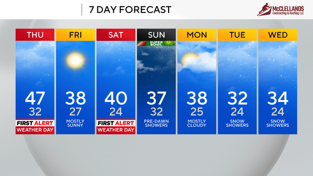
It was a little bit of a wild weather morning. Unfortunately, there was plenty of freezing rain with a number of reports of crashes due to icy roads. Icy conditions are now out of here. Our highs today won't be as warm as they looked even 24 hours ago though. I now have Pittsburgh seeing a high in just the upper 40s. A week ago it looked like we could hit 60 degrees today. This is part of an overall trend of really bringing our high temperatures that has happened over the past 24 hours as well. Saturday and Sunday both saw significant temperature forecast drops of around five degrees.
Before we begin looking too far out, let's talk about the rest of today where temperatures will hit the upper 40s before noon, and temperatures will slowly drop for the afternoon and evening hours. Midnight temperatures should be in the mid to upper 30s. Winds will be out of the west at around 10mph for the afternoon. Skies will remain overcast for the rest of the day.
Sunshine returns on Friday, but it won't be enough to overcome a very cold airmass in place. Highs on Friday will probably be hit at midnight. I have our midnight temperature at 38 degrees.
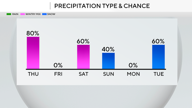
Our next hazardous weather event comes through on Saturday afternoon to evening, with a mid-level low bringing with it a chance for snow, then freezing rain, and eventually rain on Sunday morning before sunrise. Highs on Saturday will likely be hit at around midnight. I have us seeing a high of 40 degrees. The cold front pushes through between 10 p.m. and midnight. Temperatures will be dipping but will still be warm enough at midnight on Sunday to be good for the daily high temperature.
Looking way ahead, we have a chance for accumulating snow showers on Tuesday through Wednesday of next week. This looks to be the first of three snow chances that will be around for the next 10 days, starting on Tuesday and going through next Friday. There's still plenty of time for the pattern to change, but it certainly looks like we will stay active in the second and third weeks of February.
WEATHER LINKS:
Current Conditions | School Closings & Delays | Submit Your Weather Photos