Areas to the south of Pittsburgh could see accumulating snow this afternoon

Areas to the south of Pittsburgh could see accumulating snow this afternoon.
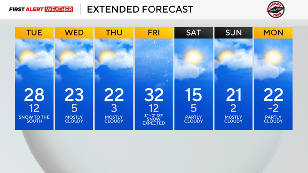
Any Alert Days Ahead? Monday will likely be a First Alert Weather Day due to dangerously low temperatures.
Aware: 1" to 3" of snow expected on Friday. Snow totals can still change due to numerous variables.
If you are traveling south today into West Virginia, just a heads up that a narrow band of snow is expected to impact the area this afternoon into the evening. 1" to 3" of snow is expected to fall from Morgantown south to just north of Burnsville. South of Burnsville will see mostly all rain. The timing of this is late this afternoon through the evening hours. The advisory expires at 1 a.m. on Wednesday for Morgantown.
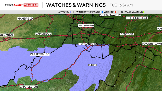
Looking at data, it really appears that most of the snow falls just south of Morgantown. Morgantown itself will probably see less than an inch of snow, although it's included in the advisory.
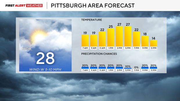
Everyone else will see just a dusting of snow today, but it will be enough that you could potential find a slick spot or two on your trip to work or school this morning. We will see a blast of frigid air this evening with temperatures plummeting to single digits by sunrise on Wednesday. I have Pittsburgh seeing a morning low of 5°. Thursday morning lows will be even colder. I have Pittsburgh seeing a low of around 3°.
Our only chance for accumulating snow for the week is set to arrive on Friday with 2" to 3" expected for our region. Snow should begin around 10 a.m. and continue through the rest of the day. This means there will be an impact on Friday afternoon for those picking up kids and driving home from work.
The weekend is looking cold with single-digit temperatures expected on Saturday & Sunday and temperatures falling below 0° on Monday morning. The good news is that I do have next Wednesday seeing a high of 40°. Let the thaw begin!
Speaking of thawing out, January is now in the books and was one for the record books. The big headline is the 11.2" of snow that we saw on Sunday, January 25th. That was good for a new daily record and is one of the larger single day snowfalls we have ever seen in Pittsburgh. We also finished out the month with back to back low temperature records being set.
On Friday, January 30th we fell down to -6° for our morning low and then fell to -11° on Saturday the 31st of January. That was the coldest temperature in Pittsburgh since January 19th, 1994. For the month we ran 5.4° colder than average. Interestingly enough, even with our record snow amount we ended up the month 0.8" shy of normal precipitation expected.
WEATHER LINKS:
Current Conditions | School Closings & Delays | Submit Your Weather Photos