Code Red now in effect in Philadelphia as wildfire smoke blankets region. Here's the weather forecast.

A NEXT Weather Alert remains in effect as thick Canadian wildfire smoke continues to blanket the Philadelphia region. Air quality has reached unhealthy levels in many locations, leading to a Code Red.
If possible, staying indoors is recommended as the wildfire smoke is creating hazy skies and unhealthy conditions. Temperatures will climb into the lower 90s in the afternoon, but humidity levels will be lower than the past couple of days.
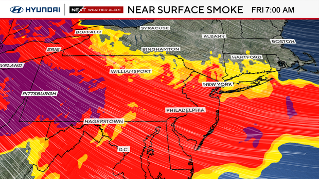
Even so, the combination of hot, smoky air can put added stress on the body. If you have to be outside, stay hydrated and take frequent breaks indoors. It's also recommended to wear a well-fitting N95 or KN95 mask if you notice heavy smoke or experience irritation.
Conditions should gradually improve later in the afternoon and into Saturday as winds shift ahead of an approaching cold front. Hazy skies may linger at times, and smoke may even return Saturday morning.
A ground delay has been issued for flights arriving at Philadelphia International Airport from 2 p.m. to 11 p.m., according to an airport spokesperson.
The dangerous air quality has also impacted a few events and attractions in the region Friday. The Philadelphia Zoo is closed for the day. In Camden County, New Jersey, officials canceled a concert at Lindenwold Park and the Movies with Metro event at Von Nieda Park.
Comedian Shane Gillis has a comedy show scheduled for Friday night at Lincoln Financial Field. The Philly-area native posted on Instagram Thursday night that the show will go on despite the smoky conditions.
NEXT big weather changes
Our attention then turns to Saturday afternoon and evening, when a cold front moves into the region.
The return of higher humidity combined with daytime heating will fuel scattered showers and thunderstorms during the afternoon and evening. Some of these storms could become severe, producing damaging wind gusts, torrential downpours, frequent lightning, localized flash flooding and even an isolated tornado. The rain will also help push much of the wildfire smoke out of the region.
A flash flood watch has been issued for the entire Philadelphia region from 10 a.m. Saturday until 2 a.m. Sunday.
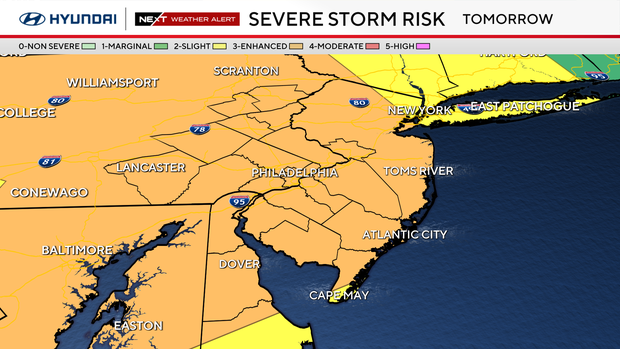
The risk of Saturday storms has been elevated to a Level 3 on a five-level scale. The area is expected to see several rounds of storms through late morning, early afternoon and early to late evening between 6 and 11 p.m.
Behind the front, Sunday looks much more comfortable with lower humidity, a mix of sun and clouds, and temperatures returning to the middle and upper 80s. It should be a pleasant finish to the weekend.
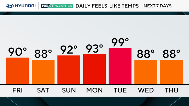
Here's your 7-day forecast:
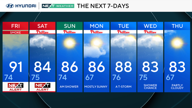
Friday: NEXT Weather Alert for smoke. High 91, low 74.
Saturday: NEXT Weather Alert. High 84, low 75.
Sunday: AM shower. High 86, low 74.
Monday: Mostly sunny. High 86, low 67.
Tuesday: Thunderstorm. High 88, low 76.
Wednesday: Shower chance. High 83, low 75.
Thursday: Partly cloudy. High 83, low 67.


