Triple digit heat continues for North Texas, but moisture remains low

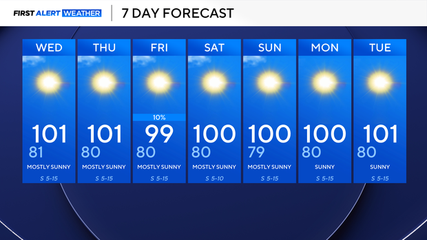
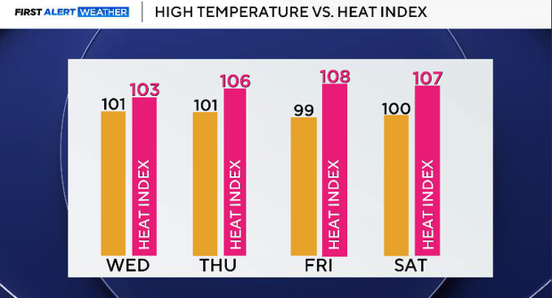
Temperatures are expected to reach 100-102 ° for most of North Texas on Tuesday, but heat index values will remain level to that of actual air temperatures, as moisture remains somewhat low, helping us stay away from heat advisory criteria.
Although we don't have heat alerts, we are under an air quality alert for Tuesday evening, as conditions are favorable for higher pollution and ozone across the metroplex. Overnight lows will stay in the low 80s Wednesday morning.
Moving through the rest of the week, temperatures will remain around the triple digits. With heat index values creeping up between 105 and 110 °. Will be watching for any potential heat advisories, with heat index values just around the necessary criteria, but we will continue to monitor that as the week progresses.
As we head into Friday and Saturday, there is a 10-20% chance of rain as the heat ridge moves to the west and helps push a weak cold front south, but it will stall out over portions of Oklahoma, and with some energy and enough moisture near North Texas, we will keep these slight rain chances, which will not amount to any meaningful accumulations.
Temperatures will remain in the upper 90s through the weekend, but once again, the triple-digit temperatures will return as we head into the start of the following week.
Long-range forecast from the Climate Prediction Center shows that we will stay with above normal temperatures and below normal precipitation through the month of August, so it looks like these hot, dry conditions will persist for quite a while throughout the month.