Mostly sunny, muggy, just a stray chance of thundershower in the Philadelphia region Saturday

The dog days of summer have settled in for the weekend.
If you are someone who enjoys the hot, humid summer days, then we encourage you to make your plans and soak in these conditions.
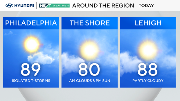
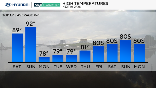
Both Saturday and Sunday are hot and humid with highs in the upper 80s to low 90s. Humidity will be high, and the heat indices (feel-like temperatures) will be in the mid- to upper 90s. Stray showers and storms are possible both days in the afternoon and evening, but once the sun sets, so do the storms.
Looking ahead, next week will be much cooler with highs only in the upper 70s and low 80s. Clouds will start the week on Monday with sunshine returning on Tuesday and a chance of showers on Wednesday.
Tracking Hurricane Erin
After a rapid intensification, Hurricane Erin is now a powerful Category 4 storm with winds of 145 mph.
It is moving WNW at 20 mph and crossing into even warmer waters, which will allow the storm to strengthen further.
Winds of 150 mph or higher are expected on Sunday. If the winds reach 157 mph, the storm will become a Category 5, the highest level on the Saffir-Simpson scale.
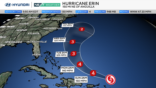
The forecast track will remain north of Puerto Rico and east of the Bahamas. It will begin turning north in the next few days, passing close to Bermuda. Erin is expected to remain a strong hurricane as it travels northward off the east coast on Wednesday and Thursday, producing high surf and dangerous rip currents along the Jersey Shore.
Here's your 7-day forecast:

Saturday: Sun, stray shower. High 89, Low 72
Sunday: Stray shower. High 92, Low 72
Monday: Cloudy, cooler. High 78, Low 71
Tuesday: Partly sunny. High 79, Low 66
Wednesday: Scattered showers. High 79, Low 66
Thursday: Partly sunny. High 81, Low 67
Friday: Partly sunny. High 83, Low 65


