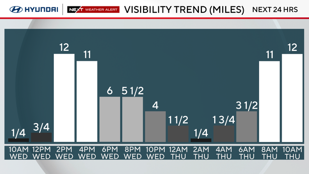
Visibility improving after foggy morning commute in Philadelphia region. Here's the weather forecast.

After a morning with fog, low clouds and light rain, visibility is beginning to improve in the Philadelphia region. A dense fog advisory for the region expired at 10 a.m., and visibility in the region is improving.
Once the fog clears, cloudy skies will stick around for most of the day along with scattered showers in the afternoon.
A Code Orange alert is in effect for all of southeastern Pennsylvania due to poor air quality levels around the region.
Light winds and quiet conditions will continue through Tuesday evening. Highs will be about average or slightly above in the mid-to-upper 40s.
The NEXT big changes
Expect average (45 degrees) or greater highs throughout the week and into the first part of the weekend, which will significantly help to melt the remaining snowpack.
We're also tracking multiple rain chances starting Wednesday, so be sure to grab the umbrella and keep it handy for the remainder of the week.
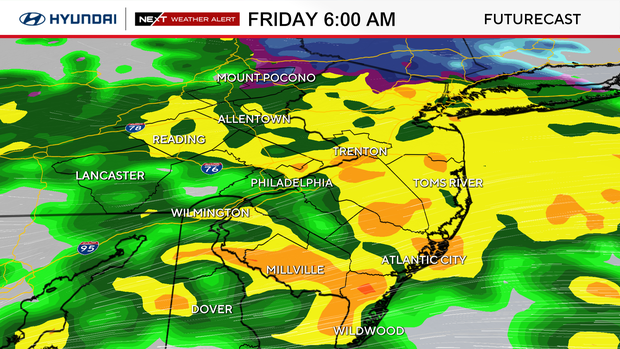
Friday morning will be one of the wettest time frames of the week, with the potential for localized flooding for the morning commute.
For Sunday, we are watching another storm that could bring rain showers, a mix, or snow, depending on the track.
It's way too early to make a call, but the NEXT Weather team will whittle down the uncertainties and have you ready for whatever next Sunday brings.
Meteorological spring is in 11 days on March 1.
Astronomical spring, aka the Vernal Equinox, is in 30 days on March 20.
Here's your weather forecast:
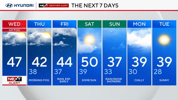
Wednesday: NEXT Weather Alert for morning fog. High 47
Thursday: More morning fog, rain showers. High 42, Low 38
Friday: Heavy rain, especially in the early hours. High 44, Low 37
Saturday: Some sun. High 50, Low 39
Sunday: Rain/snow showers. High 37, Low 33
Monday: Chilly. High 39, Low 30
Tuesday: Sunny. High 39, Low 28