Blizzard warning for Jersey Shore as coastal snow storm develops in Philadelphia region. Here's the latest.

Blizzard and winter weather warnings have been issued as a coastal, nor'easter-style snowstorm is coming to the Philadelphia area and the Jersey Shore on Sunday into Monday.
This storm could bring up to 12 inches of snow to Philadelphia and the closest areas, with even more snow possible along the coast.
We've issued a NEXT Weather Alert for this heavy snow, with potential for high winds and coastal flooding as well. Officials are already warning you to stay home Sunday night and only travel if it is an emergency, as there could be whiteout conditions that make travel very dangerous.
Power outages are also possible due to the coming snow and wind.
Read on for more about the storm. Before then, Saturday is pleasant and uneventful by comparison, with partly sunny skies, mild winds and high temperatures in the upper 40s. It's a good day to run any errands before the snow sets in.
The NEXT big change: what to know about the winter storm
This storm is a potential "bomb cyclone," meaning it could experience a large drop in pressure and thus intensify.
It is spinning up as it rounds the bottom of a deep trough in the southeast, then exits the Carolina coast and heads north along the coastline, nor'easter style.
All week, your NEXT Weather team has been closely watching the storm's track, and models were in disagreement about whether it would track closer to land, or more offshore — the closer to land, the more snow we get.
At this point, the storm looks to tuck in closer to our coastline and "bomb out" southeast of Delaware. Some call this a "winter hurricane."
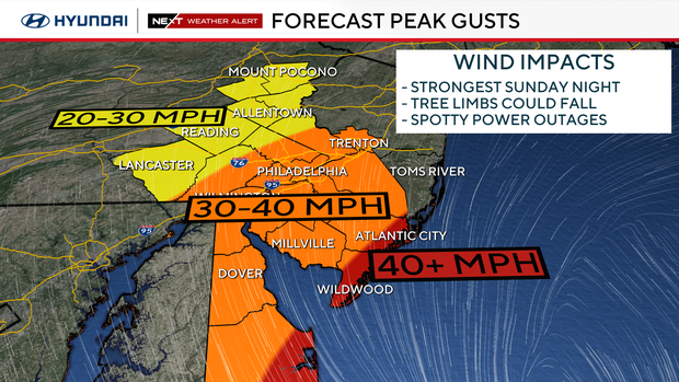
The rapid intensification will create strong winds, heavy snow and up to 2 inches of snow per hour.
This will be a warmer storm with temperatures above freezing much of the day, even in the 40s at the Shore. But temperatures will fall to near freezing by evening.
Snow can fall when temperatures are above freezing. The storm dynamics will overcome the temperature, and the snow will stick.
How much snow are we going to get?
It's important to note that this could start Sunday afternoon as rain and slushy snow, with some melting initially. In the evening, it will change to all snow across the area between 5 p.m. and 8 p.m. as temperatures hit the low 30s.
The heaviest snow will be from 9 p.m. Sunday to 6 a.m. Monday. The storm will begin to pull away rapidly between 10 a.m. and 12 p.m. Monday.
As of Saturday afternoon, it's looking like the Lehigh Valley and Berks County will receive about 4-8 inches of snow.
In Philadelphia and near the I-95 corridor, right now we expect about 8-12 inches of snow.
Closer to the coast, be prepared for 12-18 inches or more of snow.

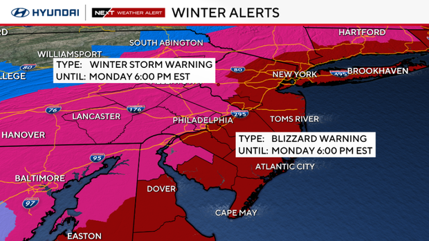
What weather alerts are in effect for the snow storm?
- A blizzard warning will take effect at 1 p.m. Sunday through 6 p.m. Monday for all coastal counties and southern Delaware.
- A winter storm warning is in effect from 5 a.m. Sunday through 6 p.m. Monday for Philadelphia and the closest surrounding counties: Delaware, Chester, Bucks, Montgomery, Gloucester, Camden, Burlington, Salem, Cumberland, New Castle and Kent.
- A winter storm watch is in effect from 4 a.m. Sunday to 6 p.m. Monday in the Lehigh Valley, Berks County and the Poconos
- A coastal flood watch is in effect from 9 p.m. Sunday to 5 p.m. Monday for all Jersey Shore points and back bays. The northeast winds with this storm will push water into the area during high tide, and moderate flooding is possible.
What should I do to prepare for the storm?
SNOW: Get snow blower, shovel, and ice melt ready.
CARS: Fuel cars, check tires, make travel kit for car.
PERSONAL: Charge all devices, preps for pets, prep for school closings and virtual learning.
TRAVEL: Be where you are going to be by Sunday evening, avoid driving unless necessary, reschedule airline flights if needed.
Here's your 7-day forecast:
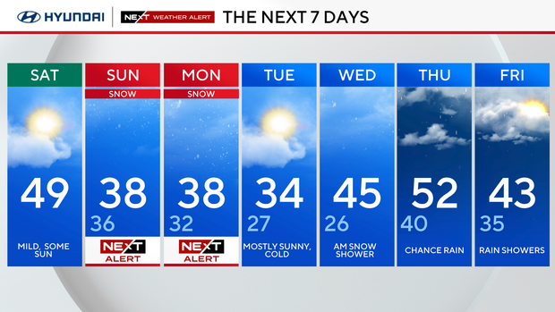
Saturday: Mild, some sun. High 50, low 37.
Sunday/NEXT Weather alert: Eye on storm. High 39, low 33.
Monday/NEXT Weather alert: Snow clears. High 38, low 32.
Tuesday: Colder. High 34, low 27.
Wednesday: Snow chance. High 46, low 27.
Thursday: Rain showers. High 51, low 40.
Friday: Partly cloudy. High 43, low 31.


