Clouds, rain with a coastal flood advisory in Philadelphia region. Here's the weather forecast.

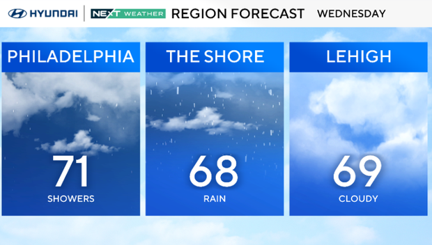
The Philadelphia region will see some rain on Wednesday, mainly in the first half of the day, as an offshore low keeps cloudy weather and showers around.
Showers will be increasingly spotty the farther inland you go, but more consistent at the Jersey Shore and Delaware beaches. A stray thunderstorm cannot be ruled out near the beaches, but no severe weather is expected.
Coastal flood advisory for tidal flooding in NJ, Del.
Our coastal areas will also have rough surf and rip currents, and a coastal flood advisory is in place at the Shore and Delaware beaches until 3 p.m. This flooding will peak at high tide, which is between 10 a.m. and 11 a.m.
The National Weather Service says up to one foot of water above ground level can be expected in low-lying areas near tidal waterways and the shoreline.
Winds stay breezy from the northeast with gusts of 20-30 mph at the shore. Highs hold in the upper 60s to low 70s, making for a cool day. Conditions turn drier by late afternoon and evening as the low pulls away, though it may take longer for the winds to ease.
There is a chance for further tidal flooding at each high tide cycle Thursday and possibly into Friday. Beyond that, the rest of the week looks quiet as sun and warmth return.
Any leftover showers end Wednesday night, followed by dry and seasonable weather Thursday and Friday as high pressure builds back in. Expect highs in the 70s to low 80s, lows in the 50s and lower humidity.
Looking ahead to the weekend, another front approaches late Sunday into early next week, but right now, rain chances appear low.
Here's your 7-day forecast:
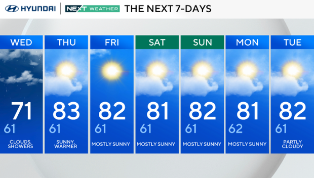
Wednesday: Clouds, showers. High 71, Low 61.
Thursday: Sunny, warmer. High 83, Low 61.
Friday: Mostly sunny. High 82, Low 61.
Saturday: Mostly sunny. High 81, Low 61.
Sunday: Mostly sunny. High 82, Low 61.
Monday: Mostly sunny. High 81, Low 62.
Tuesday: Partly cloudy. High 82, Low 61.