Mostly cloudy but warm in Philadelphia today, NEXT Weather Alert issued for severe storms Monday


The unseasonable warmth continues Sunday with mostly cloudy skies and highs either side of 70. Scattered showers are possible late tonight ahead of a strong cold front to our west.
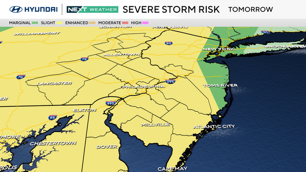
Tomorrow is a big day with the Phillies home opener. A NEXT Weather Alert has been issued for Monday afternoon through the evening as a severe storm that includes tornadoes makes its way across upper Midwest, Ohio Valley, Tennessee Valley and Deep South and toward the Delaware Valley.
NEXT Weather Alert issued for severe weather threat
This storm's severe threat moves to the East Coast, and the entire Philadelphia area, later Monday and through the night.
Heavy rain, damaging winds and intense lightning are the main threats, but there is enough spin in the atmosphere for isolated, brief tornadoes, though the greatest threat for tornadoes is across Virginia and the Carolinas.

Possible impacts include travel delays, localized flooding, power outages, downed trees and branches, and delays for the Phillies game.
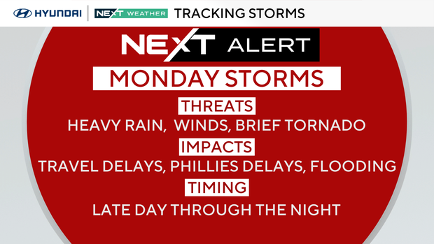
Storm timing and threats
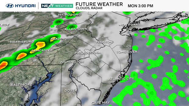
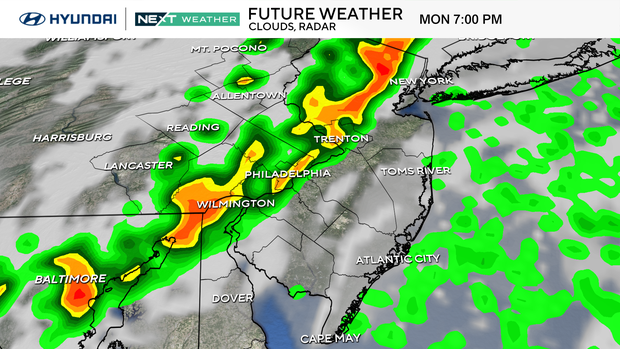
Storm timing could speed up or slow down by an hour, depending on how fast the system moves on Monday:
- 3-5 p.m.: Lehigh Valley, Berks, Poconos
- 4-6 p.m.: Philadelphia Suburbs
- 6-8 p.m.: Philly and I-95 Corridor
- 8-10 p.m.: Inland South Jersey, the Jersey Shore, and southern half of Delaware
- 11 p.m. - 1 a.m.: Exiting the Shore
Threats:
- Damaging winds
- Heavy rain (over 1 inch possible)
- Intense lightning
- Brief, isolated tornado
- Hail up to 1 inch
Phillies home opener forecast
Currently, the Phillies are scheduled to open their season at Citizens Bank Park on Monday at 3:05 p.m. against the Colorado Rockies.

It looks like we'll stay dry for first pitch, with the severe threat moving into the city after 6 p.m. However, that could change if the storm speeds up.
Our NEXT Weather team will continue to update you here, on TV, and streaming. Check back for frequent updates, and make sure to have a severe weather safety plan to protect you and your family.
- Tailgating noon-3 p.m.: Mostly cloudy, breezy, low to mid-70s.
- First pitch 3:05 p.m.: Mostly cloudy, breezy and warm, mid-70s.
- End of game 6 p.m.: Cloudy with a shower or storm possible, upper 60s to low 70s.
Behind the storm on Tuesday, temperatures will drop 20 degrees to more spring-like conditions in the mid-50s. Wednesday remains in the 50s, and by Thursday we rebound to the 70s with showers each day through next weekend
Here's your 7-day forecast
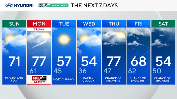
Sunday: Clouds and fog. High of 71.
Monday: NEXT Weather Alert for storms/Phillies home opener. High of 77, low of 61.
Tuesday: Mostly sunny. High of 57, low of 45.
Wednesday: Partly cloudy. High of 54, low of 36.
Thursday: Chance of showers. High of 77, low of 47.
Friday: Chance of showers. High of 68, low of 62.
Saturday: Chance of showers. High of 54, low of 50.
Get the latest weather info on the CBS News Philadelphia app.


